
Mapa topográfico Ophir
Mapa interativo
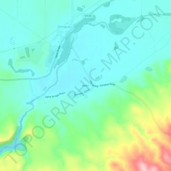
Clique no mapa para exibir a altitude.
Sobre este mapa
Nome: Mapa topográfico Ophir, altitude, relevo.
Altitude média: 338 m
Altitude mínima: 288 m
Altitude máxima: 490 m
Outros mapas topográficos
Clique em um mapa para visualizar sua topografia, sua altitude e seu relevo.
Becks
New Zealand > Otago > Central Otago District > Vincent Community
Becks, Vincent Community, Central Otago District, Otago, 9377, New Zealand
Altitude média: 393 m
Blue Lake
New Zealand > Otago > Central Otago District > Vincent Community > Saint Bathans
Blue Lake, Saint Bathans, Vincent Community, Central Otago District, Otago, New Zealand
Altitude média: 605 m
Central Otago
New Zealand > Otago > Central Otago District > Vincent Community
Central Otago, Vincent Community, Central Otago District, Otago, 9035, New Zealand
Altitude média: 935 m
Alexandra
New Zealand > Otago > Central Otago District > Vincent Community
Alexandra, Vincent Community, Central Otago District, Otago, 9320, New Zealand
Altitude média: 241 m
Blackstone Hill
New Zealand > Otago > Central Otago District > Vincent Community
Blackstone Hill, Vincent Community, Central Otago District, Otago, 9377, New Zealand
Altitude média: 789 m
Clyde
New Zealand > Otago > Central Otago District > Vincent Community
Clyde, Vincent Community, Central Otago District, Otago, 9330, New Zealand
Altitude média: 316 m
Muttontown
New Zealand > Otago > Central Otago District > Vincent Community > Clyde
Muttontown, Clyde, Vincent Community, Central Otago District, Otago, 9391, New Zealand
Altitude média: 207 m