
Mapa topográfico Shingle Creek
Mapa interativo
Clique no mapa para exibir a altitude.
Sobre este mapa
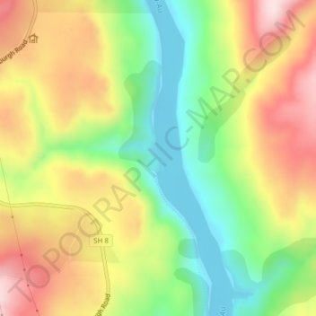
Nome: Mapa topográfico Shingle Creek, altitude, relevo.
Altitude média: 307 m
Altitude mínima: 130 m
Altitude máxima: 508 m
Outros mapas topográficos
Clique em um mapa para visualizar sua topografia, sua altitude e seu relevo.
Roxburgh
New Zealand > Otago > Central Otago District > Teviot Valley Community
Roxburgh, Teviot Valley Community, Central Otago District, Otago, 9500, New Zealand
Altitude média: 223 m
Millers Flat
New Zealand > Otago > Central Otago District > Teviot Valley Community
Millers Flat, Teviot Valley Community, Central Otago District, Otago, 9572, New Zealand
Altitude média: 161 m