
Faça uma doação
Mapa topográfico River Tay
Clique no mapa para exibir a altitude.
Faça uma doação
Sobre este mapa
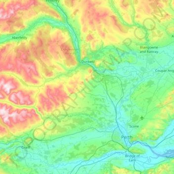
Nome: Mapa topográfico River Tay, altitude, relevo.
Local: River Tay, Perth and Kinross, Scotland, United Kingdom (56.35482 -4.00259 56.66102 -3.29671)
Altitude média: 213 m
Altitude mínima: -1 m
Altitude máxima: 801 m
Faça uma doação
Outros mapas topográficos
Clique em um mapa para visualizar sua topografia, sua altitude e seu relevo.
Glen Shee
United Kingdom > Scotland > Perth and Kinross > Spittal of Glenshee
The A93 road, part of General Wade's military road from Perth to Fort George, runs north through the glen and on into Glen Beag, where it crosses the Cairnwell Pass, which at an elevation of 2,200 feet (670 metres) is the highest public road in the UK. The road climbing to the summit is now wide and straight…
Altitude média: 387 m
Ben Lawers
United Kingdom > Scotland > Perth and Kinross
Due to its high elevation and underlying geology, Ben Lawers is home to an exceptionally rich selection of arctic-alpine plant species and habitats. Since 1964, it has been designated as a National Nature Reserve (NNR).
Altitude média: 849 m
Faça uma doação
Faça uma doação
Schiehallion
United Kingdom > Scotland > Perth and Kinross
Schiehallion lies between Loch Tay, Loch Rannoch and Loch Tummel, about 10 miles (16 kilometres) to the west-north-west of Aberfeldy in Perthshire. The mountain, with an elevation of 1,083 metres (3,553 ft), is isolated from other peaks and has an almost perfectly conical shape from the west. The view of the…
Altitude média: 652 m
Faça uma doação
Faça uma doação
Faça uma doação
Ben Vorlich
United Kingdom > Scotland > Perth and Kinross
Due to its prominence when seen from the lower ground of the Central Belt, Ben Vorlich is one of the most commonly seen of Munros, Scotland's peaks of at least 3,000 ft (914.4 m) elevation. It lies in an area of land bounded to the north by Loch Earn and to the west by Loch Lubnaig. The town of Callander lies…
Altitude média: 646 m
Faça uma doação
Faça uma doação
Faça uma doação
Alyth
United Kingdom > Scotland > Perth and Kinross
To the northeast of the town a hill fort, possibly of Pictish date or earlier, stands atop Barry (or 'barrow') Hill. It is considered to be one of the best preserved examples of an enclosed hilltop settlement in Scotland. The remains consist of massive collapsed stone ramparts that take advantage of the…
Altitude média: 125 m
Faça uma doação
Faça uma doação
Faça uma doação
Faça uma doação
Faça uma doação
Faça uma doação
The Birks of Aberfeldy
United Kingdom > Scotland > Perth and Kinross > Aberfeldy
Altitude média: 222 m
Faça uma doação
Faça uma doação
Faça uma doação
Faça uma doação
Craig Varr
United Kingdom > Scotland > Perth and Kinross > Kinloch Rannoch > Drumchastle
Altitude média: 370 m
Faça uma doação
Faça uma doação
Faça uma doação
Faça uma doação
Faça uma doação
Faça uma doação
Faça uma doação