
Faça uma doação
Mapa topográfico Titisee
Clique no mapa para exibir a altitude.
Faça uma doação
Sobre este mapa
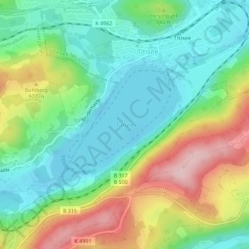
Nome: Mapa topográfico Titisee, altitude, relevo.
Altitude média: 917 m
Altitude mínima: 841 m
Altitude máxima: 1.057 m
Faça uma doação
Outros mapas topográficos
Clique em um mapa para visualizar sua topografia, sua altitude e seu relevo.
Feldberg
Germany > Baden-Württemberg > Landkreis Breisgau-Hochschwarzwald
Feldberg is a municipality in the district of Breisgau-Hochschwarzwald in Baden-Württemberg in southern Germany. It is located near the Feldberg, the highest summit in Baden-Württemberg. It comprises the settlements of Altglashütten, Neuglashütten, Falkau, Bärental, and Feldberg. At an elevation of 1,277…
Altitude média: 1.037 m
Faça uma doação
Raitenbuch
Germany > Baden-Württemberg > Landkreis Breisgau-Hochschwarzwald > Lenzkirch
Altitude média: 996 m
Bubenbach
Germany > Baden-Württemberg > Landkreis Breisgau-Hochschwarzwald
It lies at an altitude between 800 and 1130m above sea level in the Breg valley.
Altitude média: 988 m
Faça uma doação
79853
Germany > Baden-Württemberg > Landkreis Breisgau-Hochschwarzwald > Lenzkirch (Kernort)
Altitude média: 895 m
Breisach (Kernstadt)
Germany > Baden-Württemberg > Landkreis Breisgau-Hochschwarzwald > Breisach am Rhein > Hochstetten
Altitude média: 212 m
Faça uma doação
Horben
Germany > Baden-Württemberg > Landkreis Breisgau-Hochschwarzwald
Horben is located to the south of the city of Freiburg and east of the Hexental valley on the western slope of the Schauinsland mountain range. It lies between the mountains of "Illenberg" (642 m [2,106 ft]) and "Eduardshöhe" (859 m [2,818 ft]). The area is the source of the Bohrer and Selzenbach creeks.…
Altitude média: 659 m
Lenzkirch
Germany > Baden-Württemberg > Landkreis Breisgau-Hochschwarzwald
Saig is a health resort on the southern flank of the Hochfirst, and at about 1,000m elevation is the highest community in the municipality. It has about 1,200 beds available for tourists.
Altitude média: 945 m
Neustadt im Schwarzwald
Germany > Baden-Württemberg > Landkreis Breisgau-Hochschwarzwald
Altitude média: 943 m
Faça uma doação
Unadingen
Germany > Baden-Württemberg > Landkreis Breisgau-Hochschwarzwald > Löffingen
Altitude média: 763 m
Burkheim
Germany > Baden-Württemberg > Landkreis Breisgau-Hochschwarzwald > Burkheim
Altitude média: 201 m
Hartheim am Rhein
Germany > Baden-Württemberg > Landkreis Breisgau-Hochschwarzwald
Altitude média: 206 m
Horben
Germany > Baden-Württemberg > Landkreis Breisgau-Hochschwarzwald
Horben is located to the south of the city of Freiburg and east of the Hexental valley on the western slope of the Schauinsland mountain range. It lies between the mountains of "Illenberg" (642 m [2,106 ft]) and "Eduardshöhe" (859 m [2,818 ft]). The area is the source of the Bohrer and Selzenbach creeks.…
Altitude média: 659 m
Faça uma doação
Faça uma doação
Rheintal
Germany > Baden-Württemberg > Landkreis Breisgau-Hochschwarzwald > Müllheim im Markgräflerland
Altitude média: 424 m
Altglashütten
Germany > Baden-Württemberg > Landkreis Breisgau-Hochschwarzwald
Feldberg is a municipality in the district of Breisgau-Hochschwarzwald in Baden-Württemberg in southern Germany. It is located near the Feldberg, the highest summit in Baden-Württemberg. It comprises the settlements of Altglashütten, Neuglashütten, Falkau, Bärental, and Feldberg. At an elevation of 1,277…
Altitude média: 1.027 m
Faça uma doação
Gundelfingen
Germany > Baden-Württemberg > Landkreis Breisgau-Hochschwarzwald > Gundelfingen
Altitude média: 293 m
Dietenbach
Germany > Baden-Württemberg > Landkreis Breisgau-Hochschwarzwald > Kirchzarten (Kernort) > Kirchzarten
Altitude média: 482 m
Faça uma doação
Titisee-Neustadt
Germany > Baden-Württemberg > Landkreis Breisgau-Hochschwarzwald
Altitude média: 972 m
Münstertal
Germany > Baden-Württemberg > Landkreis Breisgau-Hochschwarzwald
The Münstertal stretches from Staufen im Breisgau up into the Black Forest. It divides into several side valleys and extends in the direction of Belchen(Schwarzwald), via the district of Stohren towards the Schauinsland and via the Münsterhalde towards Badenweiler. The altitude of the Münstertal ranges from…
Altitude média: 643 m
Grunern
Germany > Baden-Württemberg > Landkreis Breisgau-Hochschwarzwald > Staufen im Breisgau
Altitude média: 406 m
Faça uma doação