
Faça uma doação
Mapa topográfico Horben
Clique no mapa para exibir a altitude.
Faça uma doação
Horben
Horben is located to the south of the city of Freiburg and east of the Hexental valley on the western slope of the Schauinsland mountain range. It lies between the mountains of "Illenberg" (642 m [2,106 ft]) and "Eduardshöhe" (859 m [2,818 ft]). The area is the source of the Bohrer and Selzenbach creeks. Horben lies at an altitude above 400 m (1,300 ft) and is within the Southern Black Forest Nature park. Because of its proximity to the city of Freiburg new housing areas have been developed in the districts Langackern and Bohrer.
Faça uma doação
Sobre este mapa
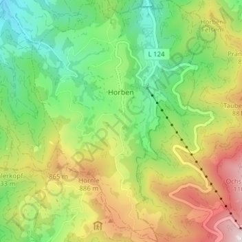
Nome: Mapa topográfico Horben, altitude, relevo.
Altitude média: 659 m
Altitude mínima: 320 m
Altitude máxima: 1.170 m
Faça uma doação
Outros mapas topográficos
Clique em um mapa para visualizar sua topografia, sua altitude e seu relevo.
Rheintal
Germany > Baden-Württemberg > Landkreis Breisgau-Hochschwarzwald > Müllheim im Markgräflerland
Altitude média: 424 m
Faça uma doação
Dietenbach
Germany > Baden-Württemberg > Landkreis Breisgau-Hochschwarzwald > Kirchzarten (Kernort) > Kirchzarten
Altitude média: 482 m