
Faça uma doação
Mapa topográfico Feldberg
Clique no mapa para exibir a altitude.
Faça uma doação
Feldberg
Feldberg is a municipality in the district of Breisgau-Hochschwarzwald in Baden-Württemberg in southern Germany. It is located near the Feldberg, the highest summit in Baden-Württemberg. It comprises the settlements of Altglashütten, Neuglashütten, Falkau, Bärental, and Feldberg. At an elevation of 1,277 m, the last is considered the highest village in Germany.
Faça uma doação
Sobre este mapa
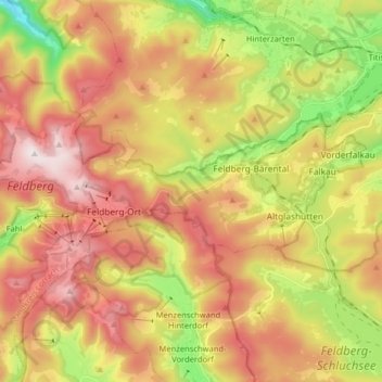
Nome: Mapa topográfico Feldberg, altitude, relevo.
Altitude média: 1.037 m
Altitude mínima: 709 m
Altitude máxima: 1.448 m
Faça uma doação
Outros mapas topográficos
Clique em um mapa para visualizar sua topografia, sua altitude e seu relevo.
Rheintal
Germany > Baden-Württemberg > Landkreis Breisgau-Hochschwarzwald > Müllheim im Markgräflerland
Altitude média: 424 m
Faça uma doação
Dietenbach
Germany > Baden-Württemberg > Landkreis Breisgau-Hochschwarzwald > Kirchzarten (Kernort) > Kirchzarten
Altitude média: 482 m