
Mapa topográfico Compton
Clique no mapa para exibir a altitude.
Compton
Compton is buffered from neighbouring settlements by cultivated fields to all sides. The village is in a gently-sloped dry valley and the fledgling Pang seasonally enters from the north west and discharges in the south east and may be joined at the centre of the village by the Roden from the north, when winter bournes rise to fill their channels. Elevations vary from 95 to 155 m (312 to 509 ft) AOD. Compton has a site of Special Scientific Interest (SSSI) just to the south west of the village, called Ashridge Wood.
Sobre este mapa
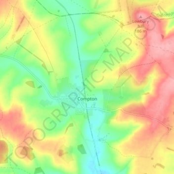
Nome: Mapa topográfico Compton, altitude, relevo.
Local: Compton, West Berkshire, England, United Kingdom (51.49604 -1.28234 51.54118 -1.21512)
Altitude média: 137 m
Altitude mínima: 88 m
Altitude máxima: 188 m
Outros mapas topográficos
Clique em um mapa para visualizar sua topografia, sua altitude e seu relevo.
Walbury Hill
United Kingdom > England > West Berkshire > Combe
Walbury Hill is a summit of the North Wessex Downs in Berkshire, England. With an elevation of 297 metres (974 ft), it is the highest natural point in South East England. On the hill's summit is the Iron Age hill fort of Walbury Camp, whilst the flanks of the hill lie within the Inkpen and Walbury Hills SSSI.…
Altitude média: 222 m