
Mapa topográfico Enborne Row
Clique no mapa para exibir a altitude.
Sobre este mapa
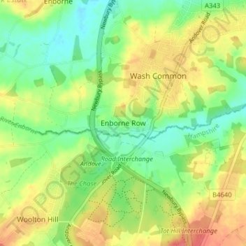
Nome: Mapa topográfico Enborne Row, altitude, relevo.
Local: Enborne Row, West Berkshire, England, RG20 0PR, United Kingdom (51.34964 -1.37675 51.38964 -1.33675)
Altitude média: 112 m
Altitude mínima: 85 m
Altitude máxima: 145 m
Outros mapas topográficos
Clique em um mapa para visualizar sua topografia, sua altitude e seu relevo.
Newbury
United Kingdom > England > West Berkshire
Elevations vary from a minimum of 72 m above mean sea level to 122 m at Wash Common. Elevations reach 150–200 m in the directly adjoining hills. The River Kennet and the Kennet and Avon Canal flow east through the centre of the town to reach the Thames at Reading, while the River Lambourn (beside which is…
Altitude média: 97 m
Streatley
United Kingdom > England > West Berkshire
Streatley is a village and civil parish on the River Thames in Berkshire, England. The village faces Goring-on-Thames. The two places share in their shops, services, leisure, sports and much of their transport. Across the river is Goring & Streatley railway station and the village cluster adjoins a lock and…
Altitude média: 95 m
Compton
United Kingdom > England > West Berkshire
Compton is buffered from neighbouring settlements by cultivated fields to all sides. The village is in a gently-sloped dry valley and the fledgling Pang seasonally enters from the north west and discharges in the south east and may be joined at the centre of the village by the Roden from the north, when winter…
Altitude média: 137 m
Compton
United Kingdom > England > West Berkshire
Compton is buffered from neighbouring settlements by cultivated fields to all sides. The village is in a gently sloped dry valley and the fledgling Pang seasonally enters from the north west and discharges in the south east and may be joined at the centre of the village by the Roden from the north, when winter…
Altitude média: 137 m
Newbury
United Kingdom > England > West Berkshire
Elevations vary from a minimum of 72 m above mean sea level to 122 m at Wash Common. Elevations reach 150–200 m in the directly adjoining hills. The River Kennet and the Kennet and Avon Canal flow east through the centre of the town to reach the Thames at Reading, while the River Lambourn (beside which is…
Altitude média: 97 m