
Mapa topográfico Ashburnham
Clique no mapa para exibir a altitude.
Sobre este mapa
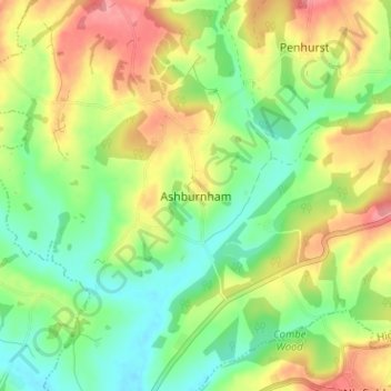
Nome: Mapa topográfico Ashburnham, altitude, relevo.
Altitude média: 42 m
Altitude mínima: 2 m
Altitude máxima: 96 m
Outros mapas topográficos
Clique em um mapa para visualizar sua topografia, sua altitude e seu relevo.
Rye
United Kingdom > England > East Sussex > Rother > Playden
The town and its striking surroundings have frequently served as subject for painters, many of whose works are now on display in its art gallery. One of the earliest topographical panoramas, dating from the 17th century when the town was still an island port, is in the style of Hendrick Danckerts and on…
Altitude média: 7 m
Rye
United Kingdom > England > East Sussex > Rother
The town and its striking surroundings have frequently served as subject for painters, many of whose works are now on display in its art gallery. One of the earliest topographical panoramas, dating from the 17th century when the town was still an island port, is in the style of Hendrick Danckerts and on…
Altitude média: 7 m