
Mapa topográfico Catsfield
Clique no mapa para exibir a altitude.
Sobre este mapa
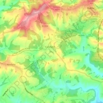
Nome: Mapa topográfico Catsfield, altitude, relevo.
Local: Catsfield, Rother, East Sussex, England, United Kingdom (50.87282 0.40648 50.91723 0.49040)
Altitude média: 53 m
Altitude mínima: 1 m
Altitude máxima: 118 m
Outros mapas topográficos
Clique em um mapa para visualizar sua topografia, sua altitude e seu relevo.
Northbridge Street
United Kingdom > England > East Sussex > Rother > Robertsbridge
Altitude média: 40 m
John's Cross
United Kingdom > England > East Sussex > Rother > Mountfield > John's Cross
Altitude média: 53 m
Union Street
United Kingdom > England > East Sussex > Rother > Flimwell > Union Street
Altitude média: 97 m
Battle of Hastings
United Kingdom > England > East Sussex > Rother > Catsfield
Battle Abbey was founded by William at the site of the battle. According to 12th-century sources, William made a vow to found the abbey, and the high altar of the church was placed at the site where Harold had died. More likely, the foundation was imposed on William by papal legates in 1070. The topography of…
Altitude média: 60 m