
Mapa topográfico Malin
Mapa interativo
Clique no mapa para exibir a altitude.
Sobre este mapa
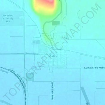
Nome: Mapa topográfico Malin, altitude, relevo.
Local: Malin, Klamath County, Oregon, United States (42.00841 -121.41529 42.01853 -121.40337)
Altitude média: 1.241 m
Altitude mínima: 1.234 m
Altitude máxima: 1.324 m
Malin is at an elevation of 4,062 feet (1,238 m) in southern Klamath County near the Oregon–California border. It is along a spur of Oregon Route 39, southeast of Klamath Falls, east of Merrill, and northeast of Tulelake. Lava Beds National Monument is to the south, nearby in California. By highway, the city is 30 miles (48 km) from Klamath Falls and 309 miles (497 km) from Portland.
Outros mapas topográficos
Clique em um mapa para visualizar sua topografia, sua altitude e seu relevo.
Klamath Falls
United States > Oregon > Klamath County
Klamath Falls, Klamath County, Oregon, 97601, United States
Altitude média: 1.312 m
Dairy
United States > Oregon > Klamath County
Dairy, Klamath County, Oregon, 97625, United States
Altitude média: 1.300 m
Crater Lake National Park
United States > Oregon > Klamath County
Crater Lake National Park, Klamath County, Oregon, 97604, United States
Altitude média: 1.726 m
Rock Point
United States > Oregon > Klamath County
Rock Point, Klamath County, Oregon, 97731, United States
Altitude média: 1.415 m
Altamont
United States > Oregon > Klamath County
Altamont, Klamath County, Oregon, 97603, United States
Altitude média: 1.310 m
Lake of the Woods
United States > Oregon > Klamath County
Lake of the Woods, Klamath County, Oregon, United States
Altitude média: 1.588 m
Chemult
United States > Oregon > Klamath County
Chemult, Klamath County, Oregon, United States
Altitude média: 1.480 m
Crescent
United States > Oregon > Klamath County
Crescent, Klamath County, Oregon, United States
Altitude média: 1.389 m
Sprague River
United States > Oregon > Klamath County
Sprague River, Klamath County, Oregon, 97639, United States
Altitude média: 1.472 m
Altamont
United States > Oregon > Klamath County > Altamont
Altamont, Klamath County, Oregon, 97603, United States
Altitude média: 1.285 m
Merrill
United States > Oregon > Klamath County
Merrill, Klamath County, Oregon, United States
Altitude média: 1.241 m
Mount Scott
United States > Oregon > Klamath County
Mount Scott, Klamath County, Oregon, United States
Altitude média: 2.295 m
Fort Klamath
United States > Oregon > Klamath County
Fort Klamath, Klamath County, Oregon, United States
Altitude média: 1.273 m
Chiloquin
United States > Oregon > Klamath County
Chiloquin, Klamath County, Oregon, United States
Altitude média: 1.302 m
Beatty
United States > Oregon > Klamath County
Beatty, Klamath County, Oregon, 97602, United States
Altitude média: 1.330 m
Odell Lake
United States > Oregon > Klamath County > Odell Lake
Odell Lake, Klamath County, Oregon, United States
Altitude média: 1.492 m
Crater Lake
United States > Oregon > Klamath County
Crater Lake, Klamath County, Oregon, United States
Altitude média: 1.971 m
Bonanza
United States > Oregon > Klamath County
Bonanza, Klamath County, Oregon, United States
Altitude média: 1.263 m
Keno
United States > Oregon > Klamath County
Keno, Klamath County, Oregon, 97627, United States
Altitude média: 1.287 m
Mount Mazama
United States > Oregon > Klamath County
Mount Mazama, Klamath County, Oregon, United States
Altitude média: 1.880 m