
Mapa topográfico Mount Scott
Mapa interativo
Clique no mapa para exibir a altitude.
Sobre este mapa
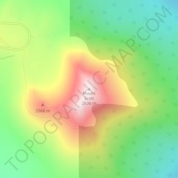
Nome: Mapa topográfico Mount Scott, altitude, relevo.
Local: Mount Scott, Klamath County, Oregon, United States (42.92295 -122.01626 42.92305 -122.01616)
Altitude média: 2.295 m
Altitude mínima: 2.004 m
Altitude máxima: 2.703 m
There is one trail to the summit of Mount Scott. Starting on Rim Drive, the trail is about 2.5 miles (4.0 km) long. It has many switchbacks, and ends at the fire lookout tower on the summit. The trailhead is at an elevation of 7,683 feet (2,342 m), and the trail climbs approximately 1,479 feet (451 m) to the top of Mount Scott at 8,934 feet (2,723 m).
Outros mapas topográficos
Clique em um mapa para visualizar sua topografia, sua altitude e seu relevo.
Klamath Falls
United States > Oregon > Klamath County
Klamath Falls, Klamath County, Oregon, 97601, United States
Altitude média: 1.312 m
Dairy
United States > Oregon > Klamath County
Dairy, Klamath County, Oregon, 97625, United States
Altitude média: 1.300 m
Crater Lake National Park
United States > Oregon > Klamath County
Crater Lake National Park, Klamath County, Oregon, 97604, United States
Altitude média: 1.726 m
Rock Point
United States > Oregon > Klamath County
Rock Point, Klamath County, Oregon, 97731, United States
Altitude média: 1.415 m
Altamont
United States > Oregon > Klamath County
Altamont, Klamath County, Oregon, 97603, United States
Altitude média: 1.310 m
Lake of the Woods
United States > Oregon > Klamath County
Lake of the Woods, Klamath County, Oregon, United States
Altitude média: 1.588 m
Chemult
United States > Oregon > Klamath County
Chemult, Klamath County, Oregon, United States
Altitude média: 1.480 m
Crescent
United States > Oregon > Klamath County
Crescent, Klamath County, Oregon, United States
Altitude média: 1.389 m
Sprague River
United States > Oregon > Klamath County
Sprague River, Klamath County, Oregon, 97639, United States
Altitude média: 1.472 m
Malin
United States > Oregon > Klamath County
Malin, Klamath County, Oregon, United States
Altitude média: 1.241 m
Altamont
United States > Oregon > Klamath County > Altamont
Altamont, Klamath County, Oregon, 97603, United States
Altitude média: 1.285 m
Merrill
United States > Oregon > Klamath County
Merrill, Klamath County, Oregon, United States
Altitude média: 1.241 m
Fort Klamath
United States > Oregon > Klamath County
Fort Klamath, Klamath County, Oregon, United States
Altitude média: 1.273 m
Chiloquin
United States > Oregon > Klamath County
Chiloquin, Klamath County, Oregon, United States
Altitude média: 1.302 m
Beatty
United States > Oregon > Klamath County
Beatty, Klamath County, Oregon, 97602, United States
Altitude média: 1.330 m
Odell Lake
United States > Oregon > Klamath County > Odell Lake
Odell Lake, Klamath County, Oregon, United States
Altitude média: 1.492 m
Crater Lake
United States > Oregon > Klamath County
Crater Lake, Klamath County, Oregon, United States
Altitude média: 1.971 m
Bonanza
United States > Oregon > Klamath County
Bonanza, Klamath County, Oregon, United States
Altitude média: 1.263 m
Keno
United States > Oregon > Klamath County
Keno, Klamath County, Oregon, 97627, United States
Altitude média: 1.287 m
Mount Mazama
United States > Oregon > Klamath County
Mount Mazama, Klamath County, Oregon, United States
Altitude média: 1.880 m