
Faça uma doação
Mapa topográfico Grillon
Clique no mapa para exibir a altitude.
Faça uma doação
Sobre este mapa
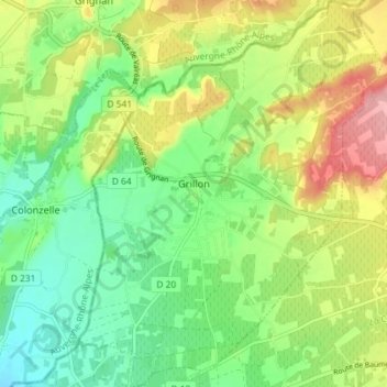
Nome: Mapa topográfico Grillon, altitude, relevo.
Altitude média: 188 m
Altitude mínima: 140 m
Altitude máxima: 262 m
Faça uma doação
Outros mapas topográficos
Clique em um mapa para visualizar sua topografia, sua altitude e seu relevo.
L'Isle-sur-la-Sorgue
France > Provence-Alpes-Côte d'Azur > Vaucluse > L'Isle-sur-la-Sorgue > L'Isle-sur-la-Sorgue
Altitude média: 80 m
Colombis
France > Provence-Alpes-Côte d'Azur > Vaucluse > Châteauneuf-du-Pape > La Croze
Altitude média: 58 m
Mont Ventoux
France > Provence-Alpes-Côte d'Azur > Vaucluse > Saint-Léger-du-Ventoux
There are two small ski stations on the mountain: "Mont Serein" on the north side, and "Chalet Reynard" on the south. High winds and the modest elevation tend to limit the ski season. Weather conditions are such that the northern slope is often icy, leading to a saying among people of the surrounding region…
Altitude média: 1.557 m
Faça uma doação
Le Rhône - Bras Mort de la Barthelasse
France > Provence-Alpes-Côte d'Azur > Vaucluse > Avignon
Altitude média: 24 m
Source du Mirail
France > Provence-Alpes-Côte d'Azur > Vaucluse > Peypin-d'Aigues
Altitude média: 493 m
Faça uma doação
Avignon
France > Provence-Alpes-Côte d'Azur > Vaucluse > Avignon
Enclosed by the city walls, the Rocher des Doms is a limestone elevation of Urgonian type, 35 metres high (and therefore safe from flooding of the Rhone which it overlooks) and is the original core of the city. Several limestone massifs are present around the commune (the Massif des Angles,…
Altitude média: 58 m
Beaumont du Ventoux
France > Provence-Alpes-Côte d'Azur > Vaucluse > Beaumont-du-Ventoux
Altitude média: 501 m
Sainte-Colombe
France > Provence-Alpes-Côte d'Azur > Vaucluse > Bédoin > Sainte-Colombe
Altitude média: 495 m
Faça uma doação