
Faça uma doação
Mapa topográfico Lourmarin
Clique no mapa para exibir a altitude.
Faça uma doação
Sobre este mapa
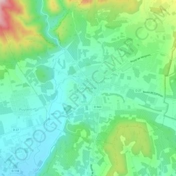
Nome: Mapa topográfico Lourmarin, altitude, relevo.
Altitude média: 259 m
Altitude mínima: 156 m
Altitude máxima: 531 m
Faça uma doação
Outros mapas topográficos
Clique em um mapa para visualizar sua topografia, sua altitude e seu relevo.
Avignon
France > Provence-Alpes-Côte d'Azur > Vaucluse
Enclosed by the city walls, the Rocher des Doms is a limestone elevation of Urgonian type, 35 metres high[18] (and therefore safe from flooding of the Rhone which it overlooks) and is the original core of the city. Several limestone massifs are present around the commune (the Massif des Angles,…
Altitude média: 39 m
Faça uma doação
Faça uma doação
Faça uma doação
Faça uma doação
Faça uma doação
Le Rhône - Bras Mort de la Barthelasse
France > Provence-Alpes-Côte d'Azur > Vaucluse > Avignon
Altitude média: 24 m
Faça uma doação
Avignon
France > Provence-Alpes-Côte d'Azur > Vaucluse
Enclosed by the city walls, the Rocher des Doms is a limestone elevation of Urgonian type, 35 metres high (and therefore safe from flooding of the Rhone which it overlooks) and is the original core of the city. Several limestone massifs are present around the commune (the Massif des Angles,…
Altitude média: 39 m
Faça uma doação
Avignon
France > Provence-Alpes-Côte d'Azur > Vaucluse
Enclosed by the city walls, the Rocher des Doms is a limestone elevation of Urgonian type, 35 metres high (and therefore safe from flooding of the Rhone which it overlooks) and is the original core of the city. Several limestone massifs are present around the commune (the Massif des Angles,…
Altitude média: 39 m
Faça uma doação
Monieux
France > Provence-Alpes-Côte d'Azur > Vaucluse
The commune is located in the zone of influence of the Mediterranean climate. The summers are hot and dry, related to the increase in altitude of the subtropical anticyclones, intersected with stormy episodes sometimes violent one. The winters are soft. Precipitations are not very frequent and rare snow. It…
Altitude média: 810 m
Faça uma doação
Faça uma doação
Faça uma doação
Faça uma doação
Faça uma doação
Faça uma doação
Faça uma doação