
Faça uma doação
Mapa topográfico Possession Island
Clique no mapa para exibir a altitude.
Faça uma doação
Possession Island
The island has been identified as an Important Bird Area (IBA) by BirdLife International as a breeding site for seabirds, of which there are at least 26 breeding species. Birds nesting in relatively large numbers include king, northern rockhopper and macaroni penguins, wandering, sooty and light-mantled albatrosses, northern giant petrels, medium-billed prions, Kerguelen and soft-plumaged petrels, and South Georgia diving petrels. Other island breeders in smaller numbers are southern giant petrels, grey-headed albatrosses and Kerguelen terns. Crozet blue-eyed shags, black-faced sheathbills and Eaton's pintails are resident. The smaller birds nest only at higher altitudes because of their vulnerability to rat predation at lower levels.
Faça uma doação
Sobre este mapa
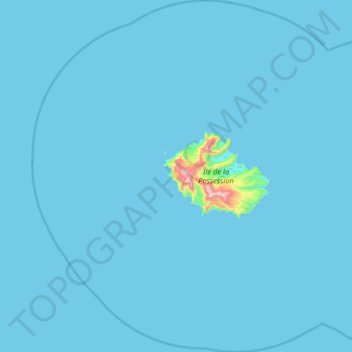
Nome: Mapa topográfico Possession Island, altitude, relevo.
Altitude média: 13 m
Altitude mínima: 0 m
Altitude máxima: 897 m
Faça uma doação
Outros mapas topográficos
Clique em um mapa para visualizar sua topografia, sua altitude e seu relevo.