
Faça uma doação
Mapa topográfico Mount Calliope
Clique no mapa para exibir a altitude.
Faça uma doação
Sobre este mapa
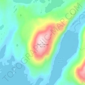
Nome: Mapa topográfico Mount Calliope, altitude, relevo.
Altitude média: 102 m
Altitude mínima: -3 m
Altitude máxima: 400 m
Faça uma doação
Outros mapas topográficos
Clique em um mapa para visualizar sua topografia, sua altitude e seu relevo.
Kerguelen Island
France > French Southern and Antarctic Lands
The highest point is Mont Ross in the Gallieni Massif, which rises along the southern coast of the island and has an elevation of 1,850 metres (6,070 ft). The Cook Ice Cap (French: Calotte Glaciaire Cook), France's largest glacier with an area of about 403 km2 (156 sq mi), lies on the west-central part of the…
Altitude média: 45 m
Kerguelen Archipelago
France > French Southern and Antarctic Lands
The highest point is Mont Ross in the Gallieni Massif, which rises along the southern coast of the island and has an elevation of 1,850 metres (6,070 ft). The Cook Ice Cap (French: Calotte Glaciaire Cook), France's largest glacier with an area of about 403 km2 (156 sq mi), lies on the west-central part of the…
Altitude média: 38 m
Faça uma doação
Kerguelen Archipelago
France > French Southern and Antarctic Lands
The highest point is Mont Ross in the Gallieni Massif, which rises along the southern coast of the island and has an elevation of 1,850 metres (6,070 ft). The Cook Ice Cap (French: Calotte Glaciaire Cook), France's largest glacier with an area of about 403 km2 (156 sq mi), lies on the west-central part of the…
Altitude média: 38 m
Faça uma doação
Kerguelen Archipelago
France > French Southern and Antarctic Lands
The highest point is Mont Ross in the Gallieni Massif, which rises along the southern coast of the island and has an elevation of 1,850 metres (6,070 ft). The Cook Ice Cap (French: Calotte Glaciaire Cook), France's largest glacier with an area of about 403 km2 (156 sq mi), lies on the west-central part of the…
Altitude média: 38 m
Faça uma doação
Possession Island
France > French Southern and Antarctic Lands
The island has been identified as an Important Bird Area (IBA) by BirdLife International as a breeding site for seabirds, of which there are at least 26 breeding species. Birds nesting in relatively large numbers include king, northern rockhopper and macaroni penguins, wandering, sooty and light-mantled…
Altitude média: 13 m
Faça uma doação