
Faça uma doação
Mapa topográfico Marble Falls
Clique no mapa para exibir a altitude.
Faça uma doação
Sobre este mapa
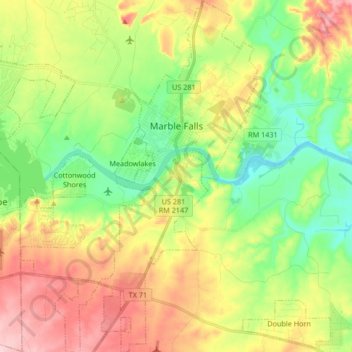
Nome: Mapa topográfico Marble Falls, altitude, relevo.
Local: Marble Falls, Burnet County, Texas, 76654, United States (30.48517 -98.33305 30.62880 -98.23707)
Altitude média: 278 m
Altitude mínima: 203 m
Altitude máxima: 382 m
Faça uma doação
Outros mapas topográficos
Clique em um mapa para visualizar sua topografia, sua altitude e seu relevo.
Inks Lake State Park
United States > Texas > Burnet County > Burnet
Conservation Pool Elevation usually stays around 888.22 ft. msl; however, this lake does fluctuate about 1 foot annually. Inks lake water clarity can be seen as clear to slightly stained mostly throughout the year. It tends to have higher turbidity during the rainy season due to excessive amounts of runoff.
Altitude média: 294 m
Faça uma doação
Briggs
United States > Texas > Burnet County
Briggs lies along U.S. Route 183 and FM 2657, northeast of Burnet. Its elevation is 1,102 feet (336 m), and it is located at 30°53′23″N 97°55′30″W / 30.88972°N 97.92500°W / 30.88972; -97.92500. Although Briggs is unincorporated, it has a post office, with the ZIP code of 78608. The…
Altitude média: 336 m
Faça uma doação
Marble Falls
United States > Texas > Burnet County > Marble Falls > Marble Falls
Altitude média: 261 m
Silver Creek Village
United States > Texas > Burnet County > Silver Creek Village
Altitude média: 347 m
Faça uma doação