
Obrigado por apoiar este site ❤️
Faça uma doação
Faça uma doação
Mapa topográfico Juns
Clique no mapa para exibir a altitude.
Obrigado por apoiar este site ❤️
Faça uma doação
Faça uma doação
Sobre este mapa
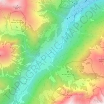
Nome: Mapa topográfico Juns, altitude, relevo.
Local: Juns, Tux, Bezirk Schwaz, Tyrol, 6192, Austria (47.11941 11.69275 47.15941 11.73275)
Altitude média: 1.752 m
Altitude mínima: 1.257 m
Altitude máxima: 2.454 m
Obrigado por apoiar este site ❤️
Faça uma doação
Faça uma doação
Outros mapas topográficos
Clique em um mapa para visualizar sua topografia, sua altitude e seu relevo.
Obrigado por apoiar este site ❤️
Faça uma doação
Faça uma doação
Obrigado por apoiar este site ❤️
Faça uma doação
Faça uma doação
Gerlos
Austria > Tyrol > Bezirk Schwaz
Gerlos is located in the de:Gerlostal, which is a side valley of the Zillertal, branching to the east near Zell am Ziller. Gerlos consists of several hamulated located along the de:Gerlospass on the floor of the valley, at an altitude of around 1200m. To the south, the side valleys of de:Schwarzach,…
Altitude média: 1.911 m
Obrigado por apoiar este site ❤️
Faça uma doação
Faça uma doação