
Faça uma doação
Mapa topográfico Gerlos
Clique no mapa para exibir a altitude.
Faça uma doação
Gerlos
Gerlos is located in the de:Gerlostal, which is a side valley of the Zillertal, branching to the east near Zell am Ziller. Gerlos consists of several hamulated located along the de:Gerlospass on the floor of the valley, at an altitude of around 1200m. To the south, the side valleys of de:Schwarzach, de:Wimmerbach, and de:Schönach lead to the Zillertal Alps, which are over 3000 meters tall. To the north, there is a ski area on the Kitzbuhel Alps.
Faça uma doação
Sobre este mapa
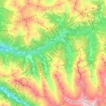
Nome: Mapa topográfico Gerlos, altitude, relevo.
Local: Gerlos, Bezirk Schwaz, Tyrol, 6281, Austria (47.13869 11.95610 47.27949 12.11112)
Altitude média: 1.911 m
Altitude mínima: 900 m
Altitude máxima: 3.245 m
Faça uma doação
Outros mapas topográficos
Clique em um mapa para visualizar sua topografia, sua altitude e seu relevo.
Faça uma doação
Faça uma doação
Faça uma doação