
Mapa topográfico Hoarwithy
Clique no mapa para exibir a altitude.
Sobre este mapa
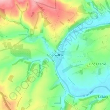
Nome: Mapa topográfico Hoarwithy, altitude, relevo.
Local: Hoarwithy, Herefordshire, England, HR2 6QH, United Kingdom (51.94037 -2.68251 51.98037 -2.64251)
Altitude média: 84 m
Altitude mínima: 34 m
Altitude máxima: 172 m
Outros mapas topográficos
Clique em um mapa para visualizar sua topografia, sua altitude e seu relevo.
Croft Castle
United Kingdom > England > Herefordshire > Yarpole
The present building dates from the 1660s during the time when Herbert Croft was Bishop of Hereford, replacing an earlier house some thirty yards to the west, which was excavated by Herefordshire County Archaeologist Prof. Keith Ray and volunteers in 2002. The manor house is a quadrangular stone structure…
Altitude média: 173 m
Eastnor Deer Park
United Kingdom > England > Herefordshire > Eastnor > Wayend Street
Altitude média: 134 m