
Mapa topográfico Welsh Bicknor
Clique no mapa para exibir a altitude.
Sobre este mapa
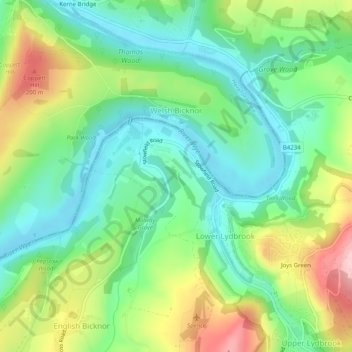
Nome: Mapa topográfico Welsh Bicknor, altitude, relevo.
Local: Welsh Bicknor, Herefordshire, England, HR9 6JJ, United Kingdom (51.83887 -2.62881 51.86397 -2.57874)
Altitude média: 96 m
Altitude mínima: 21 m
Altitude máxima: 237 m
Outros mapas topográficos
Clique em um mapa para visualizar sua topografia, sua altitude e seu relevo.
Bagpiper's Tump
United Kingdom > England > Herefordshire > Mordiford > Bagpiper's Tump
Altitude média: 88 m
Eastnor Deer Park
United Kingdom > England > Herefordshire > Eastnor > Wayend Street
Altitude média: 134 m
Hergest Ridge
United Kingdom > England > Herefordshire
Hergest Ridge is a large elongated hill which traverses the border between England and Wales in the United Kingdom, between the town of Kington in Herefordshire and the village of Gladestry in Powys. Its highest point, which is in England, is 426 metres (1,398 ft) high. It has a topographic prominence of 157.6…
Altitude média: 308 m