
Mapa topográfico The Dalles
Mapa interativo
Clique no mapa para exibir a altitude.
Sobre este mapa
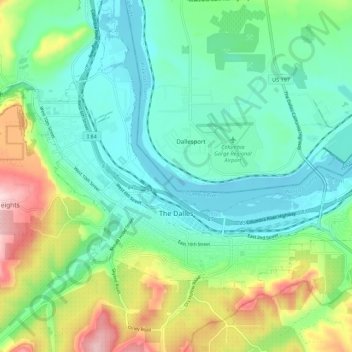
Nome: Mapa topográfico The Dalles, altitude, relevo.
Local: The Dalles, Wasco County, Oregon, United States (45.58517 -121.22910 45.64030 -121.12104)
Altitude média: 105 m
Altitude mínima: 18 m
Altitude máxima: 343 m
As in the summer, winter temperatures can vary tremendously from one day to the next. During arctic air events the daytime high temperatures will generally be well below 32 °F or 0 °C, while a strong subtropical push can raise temperatures into the 50s and low 60s F, even in January. It is quite common for relatively cold air to become trapped at low elevations due to an inversion above; depending on the temperature of the surface airmass, depth of the inversion layer, and temperatures above the inversion layer, this can result in snow, sleet, freezing rain or a very cold liquid rain.
Outros mapas topográficos
Clique em um mapa para visualizar sua topografia, sua altitude e seu relevo.
Pine Grove
United States > Oregon > Wasco County
Pine Grove, Wasco County, Oregon, United States
Altitude média: 713 m
Dant
United States > Oregon > Wasco County
Dant, Wasco County, Oregon, United States
Altitude média: 536 m
Mosier
United States > Oregon > Wasco County
Mosier, Wasco County, Oregon, United States
Altitude média: 74 m
Tygh Valley
United States > Oregon > Wasco County > Tygh Valley
Tygh Valley, Wasco County, Oregon, United States
Altitude média: 397 m
Maupin
United States > Oregon > Wasco County
Maupin, Wasco County, Oregon, United States
Altitude média: 368 m
Shaniko
United States > Oregon > Wasco County > Shaniko
Shaniko, Wasco County, Oregon, United States
Altitude média: 1.009 m
Frog Lake
United States > Oregon > Wasco County
Frog Lake, Wasco County, Oregon, United States
Altitude média: 1.266 m