
Faça uma doação
Mapa topográfico Eureka
Clique no mapa para exibir a altitude.
Faça uma doação
Eureka
Eureka is located in northern Juab County at 39°57′18″N 112°6′59″W / 39.95500°N 112.11639°W / 39.95500; -112.11639 (39.954974, -112.116364). It sits in the East Tintic Mountains at an elevation of 6,430 feet (1,960 m) above sea level. The northeast boundary of the city is the Utah County line, following the height of land. 7,828-foot (2,386 m) Packard Peak is to the north, while 8,048-foot (2,453 m) Godiva Mountain and 7,917-foot (2,413 m) Eureka Ridge are to the south.
Faça uma doação
Sobre este mapa
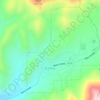
Nome: Mapa topográfico Eureka, altitude, relevo.
Local: Eureka, Juab County, Utah, United States (39.94749 -112.12847 39.97063 -112.09986)
Altitude média: 2.048 m
Altitude mínima: 1.894 m
Altitude máxima: 2.396 m
Faça uma doação
Outros mapas topográficos
Clique em um mapa para visualizar sua topografia, sua altitude e seu relevo.