
Obrigado por apoiar este site ❤️
Faça uma doação
Faça uma doação
Mapa topográfico Desert Mountain
Clique no mapa para exibir a altitude.
Obrigado por apoiar este site ❤️
Faça uma doação
Faça uma doação
Sobre este mapa
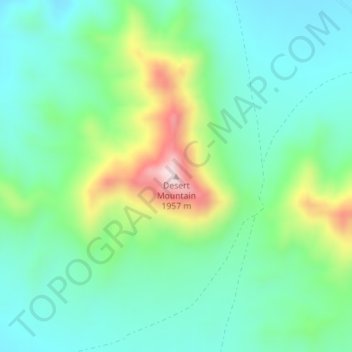
Nome: Mapa topográfico Desert Mountain, altitude, relevo.
Local: Desert Mountain, Juab County, Utah, United States (39.78129 -112.59417 39.78139 -112.59407)
Altitude média: 1.673 m
Altitude mínima: 1.563 m
Altitude máxima: 1.953 m
Obrigado por apoiar este site ❤️
Faça uma doação
Faça uma doação
Outros mapas topográficos
Clique em um mapa para visualizar sua topografia, sua altitude e seu relevo.
Eureka
United States > Utah > Juab County
Eureka is located in northern Juab County at 39°57′18″N 112°6′59″W / 39.95500°N 112.11639°W / 39.95500; -112.11639 (39.954974, -112.116364). It sits in the East Tintic Mountains at an elevation of 6,430 feet (1,960 m) above sea level. The northeast boundary of the city is the Utah County…
Altitude média: 2.048 m