
Faça uma doação
Mapa topográfico St Albans
Clique no mapa para exibir a altitude.
Faça uma doação
St Albans
The borough consisted of the ancient parish of St Albans (also known as the Abbey parish) and parts of the parishes of St Michael and St Peter. The borough was reformed by the Municipal Corporations Act 1835 to become a municipal borough, and the boundary was adjusted to additionally include part of the parish of St Stephen. On 28 August 1877 the borough gained city status, following the elevation of St Albans Abbey to become a cathedral. The boundary was also adjusted in 1877 to include part of the parish of Sandridge.
Faça uma doação
Sobre este mapa
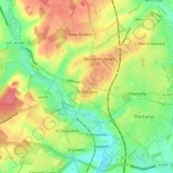
Nome: Mapa topográfico St Albans, altitude, relevo.
Local: St Albans, Hertfordshire, England, United Kingdom (51.72913 -0.37529 51.78007 -0.29102)
Altitude média: 103 m
Altitude mínima: 69 m
Altitude máxima: 141 m
Faça uma doação
Outros mapas topográficos
Clique em um mapa para visualizar sua topografia, sua altitude e seu relevo.
Kitcher's Pond
United Kingdom > England > Hertfordshire > East Hertfordshire > Albury
Altitude média: 106 m
Faça uma doação
Faça uma doação
Bushey Heath
United Kingdom > England > Hertfordshire > Hertsmere > Bushey Heath
Altitude média: 110 m
Faça uma doação