
Faça uma doação
Mapa topográfico Letchworth
Clique no mapa para exibir a altitude.
Faça uma doação
Sobre este mapa
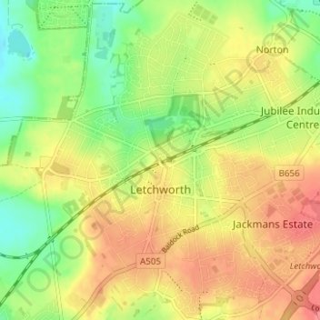
Nome: Mapa topográfico Letchworth, altitude, relevo.
Local: Letchworth, Hertfordshire, England, United Kingdom (51.95965 -0.25510 51.99937 -0.19579)
Altitude média: 81 m
Altitude mínima: 47 m
Altitude máxima: 112 m
Faça uma doação
Outros mapas topográficos
Clique em um mapa para visualizar sua topografia, sua altitude e seu relevo.
St Albans
United Kingdom > England > Hertfordshire
The borough consisted of the ancient parish of St Albans (also known as the Abbey parish) and parts of the parishes of St Michael and St Peter. The borough was reformed by the Municipal Corporations Act 1835 to become a municipal borough, and the boundary was adjusted to additionally include part of the parish…
Altitude média: 103 m
Faça uma doação
Faça uma doação
Faça uma doação
Faça uma doação
Bushey Heath
United Kingdom > England > Hertfordshire > Hertsmere > Bushey Heath
Altitude média: 110 m
Bishop's Stortford
United Kingdom > England > Hertfordshire > East Hertfordshire
Stortford, along with the rest of Britain, has a temperate maritime climate, with cool summers and mild winters. The nearest weather station for which averages and extremes are available is Stansted Airport, about 2+1⁄2 miles (4 kilometres) due east of Stortford's town centre. Located at an elevation of over…
Altitude média: 83 m
Faça uma doação