
Faça uma doação
Mapa topográfico Saumane-de-Vaucluse
Clique no mapa para exibir a altitude.
Faça uma doação
Sobre este mapa
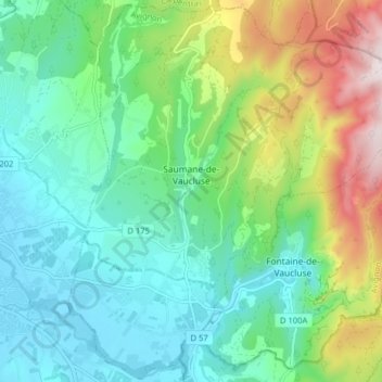
Nome: Mapa topográfico Saumane-de-Vaucluse, altitude, relevo.
Altitude média: 230 m
Altitude mínima: 60 m
Altitude máxima: 664 m
Faça uma doação
Outros mapas topográficos
Clique em um mapa para visualizar sua topografia, sua altitude e seu relevo.
Beaumont du Ventoux
France > Provence-Alpes-Côte d'Azur > Vaucluse > Beaumont-du-Ventoux
Altitude média: 501 m
Avignon
France > Provence-Alpes-Côte d'Azur > Vaucluse > Avignon
Enclosed by the city walls, the Rocher des Doms is a limestone elevation of Urgonian type, 35 metres high (and therefore safe from flooding of the Rhone which it overlooks) and is the original core of the city. Several limestone massifs are present around the commune (the Massif des Angles,…
Altitude média: 58 m
Faça uma doação
Château de Saumane
France > Provence-Alpes-Côte d'Azur > Vaucluse > Saumane-de-Vaucluse
Altitude média: 234 m
Faça uma doação
Les Tambours
France > Provence-Alpes-Côte d'Azur > Vaucluse > Saint-Saturnin-lès-Apt
Altitude média: 547 m