
Obrigado por apoiar este site ❤️
Faça uma doação
Faça uma doação
Mapa topográfico Avignon
Clique no mapa para exibir a altitude.
Obrigado por apoiar este site ❤️
Faça uma doação
Faça uma doação
Avignon
Enclosed by the city walls, the Rocher des Doms is a limestone elevation of Urgonian type, 35 metres high (and therefore safe from flooding of the Rhone which it overlooks) and is the original core of the city. Several limestone massifs are present around the commune (the Massif des Angles, Villeneuve-lès-Avignon, Alpilles...) and they are partly the result of the oceanisation of the Ligurian-Provençal basin following the migration of the Sardo-Corsican block.
Obrigado por apoiar este site ❤️
Faça uma doação
Faça uma doação
Sobre este mapa
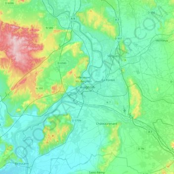
Nome: Mapa topográfico Avignon, altitude, relevo.
Altitude média: 58 m
Altitude mínima: 3 m
Altitude máxima: 273 m
Obrigado por apoiar este site ❤️
Faça uma doação
Faça uma doação