
Mapa topográfico Berkshire
Mapa interativo
Clique no mapa para exibir a altitude.
Sobre este mapa
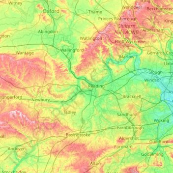
Nome: Mapa topográfico Berkshire, altitude, relevo.
Local: Berkshire, West Berkshire, England, United Kingdom (51.32896 -1.58809 51.57783 -0.49004)
Altitude média: 100 m
Altitude mínima: 11 m
Altitude máxima: 294 m
All of the county is drained by the Thames. Berkshire divides into two topological (and associated geological) sections: east and west of Reading. North-east Berkshire has the low calciferous (limestone) m-shaped bends of the Thames south of which is a broader, clayey, gravelly former watery plain or belt from Earley to Windsor and beyond, south, are parcels and belts of uneroded higher sands, flints, shingles and lightly acid soil and in the north of the Bagshot Formation, north of Surrey and Hampshire. Swinley Forest (also known as Bracknell Forest), Windsor Great Park, Crowthorne and Stratfield Saye Woods have many pine, silver birch, and other lightly acid-soil trees. East of the grassy and wooded bends a large minority of East Berkshire's land mirrors the clay belt, being of low elevation and on the left (north) bank of the Thames: Slough, Eton, Eton Wick, Wraysbury, Horton, and Datchet. In the heart of the county Reading's northern suburb Caversham is also on that bank, but rises steeply into the Chiltern Hills.
Outros mapas topográficos
Clique em um mapa para visualizar sua topografia, sua altitude e seu relevo.
Welford
United Kingdom > England > West Berkshire
Welford, West Berkshire, England, United Kingdom
Altitude média: 124 m
Great Shefford
United Kingdom > England > West Berkshire
Great Shefford, West Berkshire, England, United Kingdom
Altitude média: 148 m
Bradfield
United Kingdom > England > West Berkshire
Bradfield, West Berkshire, England, United Kingdom
Altitude média: 77 m
Shaw
United Kingdom > England > West Berkshire
Shaw, West Berkshire, England, RG14 2DF, United Kingdom
Altitude média: 93 m
Hungerford
United Kingdom > England > West Berkshire
Hungerford, West Berkshire, England, United Kingdom
Altitude média: 131 m
Newbury
United Kingdom > England > West Berkshire
Newbury, West Berkshire, England, United Kingdom
Altitude média: 97 m
Mortimer
United Kingdom > England > West Berkshire > Mortimer
Mortimer, West Berkshire, South East England, England, RG7 3RD, United Kingdom
Altitude média: 80 m
Reading
United Kingdom > England > West Berkshire > Reading
Reading, West Berkshire, South East England, England, RG1 1DA, United Kingdom
Altitude média: 56 m
Burghfield
United Kingdom > England > West Berkshire > Burghfield
Burghfield, West Berkshire, England, United Kingdom
Altitude média: 53 m
Brightwalton
United Kingdom > England > West Berkshire
Brightwalton, West Berkshire, England, United Kingdom
Altitude média: 178 m
Pangbourne
United Kingdom > England > West Berkshire > Pangbourne
Pangbourne, West Berkshire, South East England, England, United Kingdom
Altitude média: 64 m
Beenham
United Kingdom > England > West Berkshire > Beenham
Beenham, West Berkshire, South East England, England, United Kingdom
Altitude média: 77 m