
Obrigado por apoiar este site ❤️
Faça uma doação
Faça uma doação
Mapa topográfico Great Shefford
Clique no mapa para exibir a altitude.
Obrigado por apoiar este site ❤️
Faça uma doação
Faça uma doação
Sobre este mapa
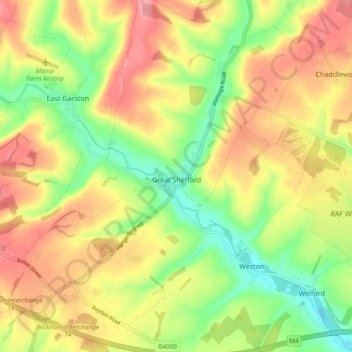
Nome: Mapa topográfico Great Shefford, altitude, relevo.
Local: Great Shefford, West Berkshire, England, United Kingdom (51.44746 -1.49043 51.50569 -1.42143)
Altitude média: 148 m
Altitude mínima: 93 m
Altitude máxima: 201 m
Obrigado por apoiar este site ❤️
Faça uma doação
Faça uma doação
Outros mapas topográficos
Clique em um mapa para visualizar sua topografia, sua altitude e seu relevo.