
Faça uma doação
Mapa topográfico Rainbow Curve Overlook
Clique no mapa para exibir a altitude.
Faça uma doação
Sobre este mapa
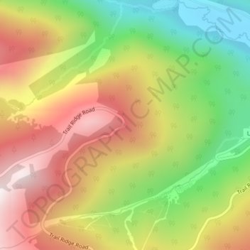
Nome: Mapa topográfico Rainbow Curve Overlook, altitude, relevo.
Altitude média: 3.043 m
Altitude mínima: 2.608 m
Altitude máxima: 3.471 m
Faça uma doação
Outros mapas topográficos
Clique em um mapa para visualizar sua topografia, sua altitude e seu relevo.
Estes Park
United States > Colorado > Larimer County
Estes Park sits at an elevation of 7,522 feet (2,293 m) on the front range of the Rocky Mountains at the eastern entrance of the Rocky Mountain National Park. Its location is 40°22′22″N 105°31′09″W / 40.372856°N 105.519136°W / 40.372856; -105.519136. Its north, south and east extremities…
Altitude média: 2.409 m
Rawah Wilderness
United States > Colorado > Larimer County
The Rawah Wilderness is administered by the USDA Forest Service. It is located on the Canyon Lakes Ranger District of the Roosevelt National Forest in Colorado, near the Wyoming border, and also in the Routt National Forest to its south. It encompasses 76,394 acres (309.16 km2) and includes 25 named lakes…
Altitude média: 2.898 m
Faça uma doação
Faça uma doação
Lake Estes
United States > Colorado > Larimer County > Estes Park > Stanley Heights Subdivision
Altitude média: 2.318 m
Faça uma doação
Faça uma doação
Neota Wilderness
United States > Colorado > Larimer County
The Neota Wilderness is administered by the USDA Forest Service. It is located on the Canyon Lakes Ranger District of the Roosevelt National Forest in Colorado. This wilderness area encompasses 9,924 acres (40 km2) and is bordered on the south by Rocky Mountain National Park. Elevation ranges from 10,000 ft…
Altitude média: 3.254 m
Faça uma doação