
Faça uma doação
Mapa topográfico Coolnahila (Palmer)
Clique no mapa para exibir a altitude.
Faça uma doação
Sobre este mapa
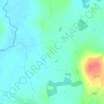
Nome: Mapa topográfico Coolnahila (Palmer), altitude, relevo.
Altitude média: 39 m
Altitude mínima: 27 m
Altitude máxima: 84 m
Faça uma doação
Outros mapas topográficos
Clique em um mapa para visualizar sua topografia, sua altitude e seu relevo.
Kilcruaig
Ireland > County Limerick > The Municipal District of Cappamore — Kilmallock
Altitude média: 200 m
Knockadea
Ireland > County Limerick > The Municipal District of Cappamore — Kilmallock
Altitude média: 203 m
Pallasgreen
Ireland > County Limerick > The Municipal District of Cappamore — Kilmallock
Altitude média: 72 m
Galtymore
Ireland > County Limerick > The Municipal District of Cappamore — Kilmallock
Galtymore or Galteemore (Irish: Cnoc Mór na nGaibhlte, meaning 'big hill of the Galtees') is a mountain in the province of Munster, Ireland. At 917.9 metres (3,011 ft 6 in), it is one of Ireland's highest mountains, being the 12th-highest on the Arderin list, and 14th-highest on the Vandeleur-Lynam list.…
Altitude média: 594 m
Faça uma doação
Aherlow
Ireland > County Limerick > The Municipal District of Cappamore — Kilmallock
Altitude média: 141 m
Clare Glens
Ireland > County Limerick > The Municipal District of Cappamore — Kilmallock
Altitude média: 124 m
Ardpatrick
Ireland > County Limerick > The Municipal District of Cappamore — Kilmallock
Altitude média: 169 m
Bruff
Ireland > County Limerick > The Municipal District of Cappamore — Kilmallock
Altitude média: 68 m
Faça uma doação
Bruree
Ireland > County Limerick > The Municipal District of Cappamore — Kilmallock
Altitude média: 62 m