
Mapa topográfico Ardpatrick
Clique no mapa para exibir a altitude.
Sobre este mapa
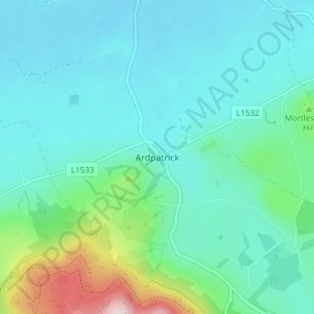
Nome: Mapa topográfico Ardpatrick, altitude, relevo.
Altitude média: 169 m
Altitude mínima: 111 m
Altitude máxima: 428 m
Outros mapas topográficos
Clique em um mapa para visualizar sua topografia, sua altitude e seu relevo.
Cullane South
Ireland > County Limerick > The Municipal District of Cappamore — Kilmallock
Altitude média: 152 m
Kilmallock
Ireland > County Limerick > The Municipal District of Cappamore — Kilmallock
Altitude média: 89 m
Kilmurry
Ireland > County Limerick > The Municipal District of Cappamore — Kilmallock
Altitude média: 90 m
Kilfinnane
Ireland > County Limerick > The Municipal District of Cappamore — Kilmallock
At an elevation of over 150 metres (500 ft), Kilfinnane is the highest town in County Limerick. It is surrounded on three sides by the Ballyhoura Mountains, and on the fourth side is the "Golden Vale" region that runs through Counties Limerick, Cork, and Tipperary.
Altitude média: 160 m
Darranstown
Ireland > County Limerick > The Municipal District of Cappamore — Kilmallock
Altitude média: 108 m
Ballylanders
Ireland > County Limerick > The Municipal District of Cappamore — Kilmallock
Altitude média: 157 m
Knockainy
Ireland > County Limerick > The Municipal District of Cappamore — Kilmallock
Altitude média: 86 m
Drombane
Ireland > County Limerick > The Municipal District of Cappamore — Kilmallock
Altitude média: 50 m
Aherlow
Ireland > County Limerick > The Municipal District of Cappamore — Kilmallock
Altitude média: 141 m
Clare Glens
Ireland > County Limerick > The Municipal District of Cappamore — Kilmallock
Altitude média: 124 m
Glenstal
Ireland > County Limerick > The Municipal District of Cappamore — Kilmallock
Altitude média: 147 m
Coolnahila (Palmer)
Ireland > County Limerick > The Municipal District of Cappamore — Kilmallock
Altitude média: 39 m
Coolattin
Ireland > County Limerick > The Municipal District of Cappamore — Kilmallock
Altitude média: 222 m
Caherconlish
Ireland > County Limerick > The Municipal District of Cappamore — Kilmallock
Altitude média: 79 m
Coolfree
Ireland > County Limerick > The Municipal District of Cappamore — Kilmallock
Altitude média: 254 m
Tobernea
Ireland > County Limerick > The Municipal District of Cappamore — Kilmallock
Altitude média: 93 m
Anglesborough
Ireland > County Limerick > The Municipal District of Cappamore — Kilmallock
Altitude média: 229 m
Barna
Ireland > County Limerick > The Municipal District of Cappamore — Kilmallock
Altitude média: 249 m
Dromin
Ireland > County Limerick > The Municipal District of Cappamore — Kilmallock
Altitude média: 73 m
Garranbane
Ireland > County Limerick > The Municipal District of Cappamore — Kilmallock
Altitude média: 143 m
Ballyvalode
Ireland > County Limerick > The Municipal District of Cappamore — Kilmallock
Altitude média: 66 m
Ballysallagh
Ireland > County Limerick > The Municipal District of Cappamore — Kilmallock
Altitude média: 80 m
Knocknascrow
Ireland > County Limerick > The Municipal District of Cappamore — Kilmallock
Altitude média: 306 m
Tullabeg
Ireland > County Limerick > The Municipal District of Cappamore — Kilmallock
Altitude média: 67 m
Oola
Ireland > County Limerick > The Municipal District of Cappamore — Kilmallock
Altitude média: 77 m
Nicker
Ireland > County Limerick > The Municipal District of Cappamore — Kilmallock
Altitude média: 83 m
Kilmallock
Ireland > County Limerick > The Municipal District of Cappamore — Kilmallock
Altitude média: 90 m
Muingacree
Ireland > County Limerick > The Municipal District of Cappamore — Kilmallock
Altitude média: 268 m
Kilflynn Particles Parish Union
Ireland > County Limerick > The Municipal District of Cappamore — Kilmallock
Altitude média: 211 m
Toomaline Upper
Ireland > County Limerick > The Municipal District of Cappamore — Kilmallock
Altitude média: 122 m
Pallasbeg
Ireland > County Limerick > The Municipal District of Cappamore — Kilmallock
Altitude média: 49 m
Ballinscaula
Ireland > County Limerick > The Municipal District of Cappamore — Kilmallock
Altitude média: 106 m
Ballyshoneen
Ireland > County Limerick > The Municipal District of Cappamore — Kilmallock
Altitude média: 79 m
Doon South
Ireland > County Limerick > The Municipal District of Cappamore — Kilmallock
Altitude média: 101 m
Anglesborough
Ireland > County Limerick > The Municipal District of Cappamore — Kilmallock
Altitude média: 229 m
Doon
Ireland > County Limerick > The Municipal District of Cappamore — Kilmallock
Altitude média: 112 m
Brickfield
Ireland > County Limerick > The Municipal District of Cappamore — Kilmallock
Altitude média: 123 m
Mounteagle
Ireland > County Limerick > The Municipal District of Cappamore — Kilmallock
Altitude média: 63 m
Dead
Ireland > County Limerick > The Municipal District of Cappamore — Kilmallock
Altitude média: 62 m