
Faça uma doação
Mapa topográfico Lake Powell
Clique no mapa para exibir a altitude.
Faça uma doação
Lake Powell
Concrete placement started around the clock on June 17, 1960. The last bucket of concrete was poured on September 13, 1963. Over 5 million cubic yards (4,000,000 m³) of concrete make up Glen Canyon Dam. The dam is 710 feet (216 m) high and the surface elevation of the water at full-pool is approximately 3700 feet (1100 m). Construction of the dam cost $155 million, and 18 people died in the process. From 1970 to 1980, turbines and generators were installed for hydroelectricity. On September 22, 1966, Glen Canyon Dam was dedicated by Lady Bird Johnson.
Faça uma doação
Sobre este mapa
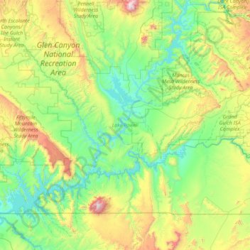
Nome: Mapa topográfico Lake Powell, altitude, relevo.
Local: Lake Powell, San Juan County, Utah, United States (36.84441 -111.56748 37.90938 -110.28672)
Altitude média: 1.555 m
Altitude mínima: 1.103 m
Altitude máxima: 3.236 m
Faça uma doação
Outros mapas topográficos
Clique em um mapa para visualizar sua topografia, sua altitude e seu relevo.