
Faça uma doação
Mapa topográfico Valley of the Gods
Clique no mapa para exibir a altitude.
Faça uma doação
Sobre este mapa
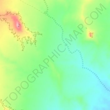
Nome: Mapa topográfico Valley of the Gods, altitude, relevo.
Local: Valley of the Gods, San Juan County, Utah, United States (37.23272 -109.87033 37.25272 -109.85033)
Altitude média: 1.403 m
Altitude mínima: 1.354 m
Altitude máxima: 1.494 m
Faça uma doação
Outros mapas topográficos
Clique em um mapa para visualizar sua topografia, sua altitude e seu relevo.
Monticello
United States > Utah > San Juan County
Monticello is located at the base of the Abajo Mountains, or the Blue Mountains, which are part of the Manti-La Sal National Forest. The elevation of Monticello is 7,069 feet (2,155 m). From Monticello, a tree formation on the Blue Mountains can be seen, which resembles a horse's head and neck, which can be…
Altitude média: 2.145 m
Lake Powell
United States > Utah > San Juan County
Concrete placement started around the clock on June 17, 1960. The last bucket of concrete was poured on September 13, 1963. Over 5 million cubic yards (4,000,000 m³) of concrete make up Glen Canyon Dam. The dam is 710 feet (216 m) high and the surface elevation of the water at full-pool is approximately 3700…
Altitude média: 1.555 m
Faça uma doação
Oljato–Monument Valley
United States > Utah > San Juan County
Oljato–Monument Valley is located at 37°0′38″N 110°14′34″W / 37.01056°N 110.24278°W / 37.01056; -110.24278 (37.010556, -110.242778), at an elevation of 1,475 m (4,840 feet).
Altitude média: 1.557 m
Faça uma doação
Faça uma doação
Faça uma doação
Fish Creek Canyon Wilderness Study Area
United States > Utah > San Juan County
Altitude média: 1.817 m