
Faça uma doação
Mapa topográfico Grande Prairie
Clique no mapa para exibir a altitude.
Faça uma doação
Grande Prairie
Grande Prairie is located just north of the 55th parallel north, and is 465 km (289 mi) northwest of Edmonton, lying at an elevation of 669 metres (2,195 ft) above sea level. The city is surrounded by farmland to the north, east, and west. To the south lies a vast boreal forest with aspen, tamarack, lodgepole pine, jack pine, and black spruce extending well into the foothills of the Canadian Rockies south and southwest of the city. The city actually lies on the southern edge of aspen parkland, which is a transitional biome between boreal forest and prairie. The Peace River Country contains the northernmost area of aspen parkland in North America.
Faça uma doação
Sobre este mapa
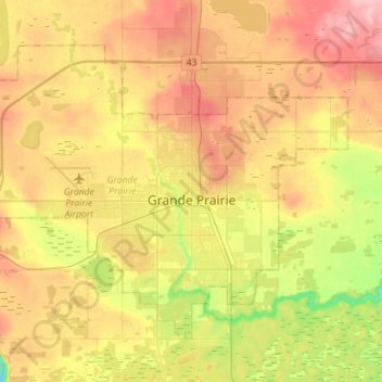
Nome: Mapa topográfico Grande Prairie, altitude, relevo.
Local: Grande Prairie, Alberta, Canada (55.11247 -118.96176 55.23618 -118.67955)
Altitude média: 665 m
Altitude mínima: 605 m
Altitude máxima: 726 m
Faça uma doação
Outros mapas topográficos
Clique em um mapa para visualizar sua topografia, sua altitude e seu relevo.
Lethbridge
Canada > Alberta > Lethbridge
Its high elevation of 929 m (3,047.9 ft) and close proximity to the Rocky Mountains provides Lethbridge with cooler summers than other locations in the Canadian Prairies. These factors protect the city from strong northwest and southwest winds and contribute to frequent chinook winds during the winter.…
Altitude média: 918 m
Banff
Canada > Alberta > Banff > Banff
Banff is a town within Banff National Park in Alberta, Canada. It is located in Alberta's Rockies along the Trans-Canada Highway, approximately 126 km (78 mi) west of Calgary and 58 km (36 mi) east of Lake Louise. At 1,400 to 1,630 m (4,590 to 5,350 ft) above sea level, Banff is the community with the second…
Altitude média: 1.615 m
Faça uma doação
Faça uma doação
Faça uma doação
Canmore
Canada > Alberta > Town of Canmore
Elevation Place opened in April 2013 as Canmore's new recreation facility. Construction of the facility began in 2012 to replace the Canmore Recreation Centre (the community's old facility). The facility offers an 8-lane 25m lap pool, a world class climbing wall developed by Walltopia, two cardio rooms, a…
Altitude média: 1.565 m
Faça uma doação
Faça uma doação
Faça uma doação
Faça uma doação
Faça uma doação
Faça uma doação
Faça uma doação
Faça uma doação
Faça uma doação
Faça uma doação
Faça uma doação
Faça uma doação
Faça uma doação
Faça uma doação
Faça uma doação
Faça uma doação
Faça uma doação
Faça uma doação
Wetaskiwin
Canada > Alberta > Wetaskiwin
The city lies at an elevation of 760 m (2,490 ft). Coal Lake, a reservoir developed on the Battle River is located immediately east of the city, and other nearby waterways include Pipestone Creek, Bigstone Creek, Bittern Lake and Bearhills Lake.
Altitude média: 770 m
Cochrane
Canada > Alberta > Town of Cochrane > Cochrane
Cochrane is situated at the base of Big Hill in the Bow River Valley. It sits at an elevation of 1,186 m (3,891 ft). The town is intersected by Highway 1A and Highway 22. Cochrane has a reputation for its western culture, which can easily be felt when one wanders the streets (particularly Main Street). The…
Altitude média: 1.205 m
Faça uma doação
Faça uma doação
Faça uma doação
Faça uma doação