
Faça uma doação
Mapa topográfico Lethbridge
Clique no mapa para exibir a altitude.
Faça uma doação
Lethbridge
Its high elevation of 929 m (3,047.9 ft) and close proximity to the Rocky Mountains provides Lethbridge with cooler summers than other locations in the Canadian Prairies. These factors protect the city from strong northwest and southwest winds and contribute to frequent chinook winds during the winter. Lethbridge winters have the highest temperatures in the prairies, reducing the severity and duration of winter cold periods and resulting in fewer days with snow cover. The average daytime temperature peaks by the end of July/beginning of August, when it reaches 26.4 °C (79.5 °F). The city's temperature reaches a maximum high of 35 °C (95 °F) or greater on average once or twice a year.
Faça uma doação
Sobre este mapa
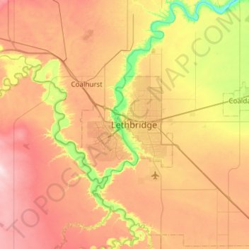
Nome: Mapa topográfico Lethbridge, altitude, relevo.
Local: Lethbridge, City of Lethbridge, Alberta, T1J 4L3, Canada (49.53429 -113.01156 49.85429 -112.69156)
Altitude média: 918 m
Altitude mínima: 782 m
Altitude máxima: 1.056 m
Faça uma doação
Outros mapas topográficos
Clique em um mapa para visualizar sua topografia, sua altitude e seu relevo.