
Obrigado por apoiar este site ❤️
Faça uma doação
Faça uma doação
Mapa topográfico Machachi
Clique no mapa para exibir a altitude.
Obrigado por apoiar este site ❤️
Faça uma doação
Faça uma doação
Machachi
Machachi is located to the south of the capital of Ecuador, Quito. It is a city surrounded by the volcanos Atacazo, Corazon, Rumiñahui, Illinizas Peaks, Viudita Hill, Pasochoa, and Sincholagua, and owns part of the Cotopaxi volcano, a great active volcano which measures 5,897 m (19,347 ft) in altitude. In fact, the valley owns eight volcanoes inside, one the reasons Alexander von Humboldt named the region "Avenue of Volcanoes".
Obrigado por apoiar este site ❤️
Faça uma doação
Faça uma doação
Sobre este mapa
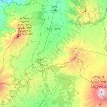
Nome: Mapa topográfico Machachi, altitude, relevo.
Local: Machachi, Pichincha, Ecuador (-0.72106 -78.60579 -0.43621 -78.32060)
Altitude média: 3.542 m
Altitude mínima: 2.398 m
Altitude máxima: 5.853 m
Obrigado por apoiar este site ❤️
Faça uma doação
Faça uma doação
Outros mapas topográficos
Clique em um mapa para visualizar sua topografia, sua altitude e seu relevo.