
Faça uma doação
Mapa topográfico New Brunswick
Clique no mapa para exibir a altitude.
Faça uma doação
Sobre este mapa
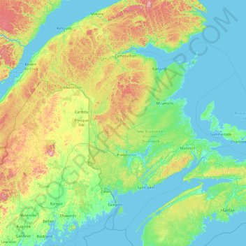
Nome: Mapa topográfico New Brunswick, altitude, relevo.
Local: New Brunswick, Canada (43.94028 -69.31018 49.06028 -64.19018)
Altitude média: 165 m
Altitude mínima: -3 m
Altitude máxima: 1.412 m
Faça uma doação
Outros mapas topográficos
Clique em um mapa para visualizar sua topografia, sua altitude e seu relevo.
Fredericton
Canada > New Brunswick > Kingsclear Parish > Fredericton
At an altitude of about 17 m (56 ft) above sea level, Fredericton is nestled in the Pennsylvanian Basin. It differs markedly from the geologically older parts of the province. There are prominently two distinct areas in the region that are divided around the area of Wilsey Road, in the east end of the city. In…
Altitude média: 72 m
City of Fredericton
At an altitude of about 17 m (56 ft) above sea level, Fredericton is nestled in the Pennsylvanian Basin. It differs markedly from the geologically older parts of the province. There are prominently two distinct areas in the region that are divided around the area of Wilsey Road, in the east end of the city. In…
Altitude média: 71 m
Faça uma doação
Faça uma doação
Fundy National Park of Canada
Canada > New Brunswick > Fundy Albert > Alma Parish
According to the Commission for Environmental Cooperation, the park is located in the Level III- Eastern Temperate Forests (Maine-New Brunswick Plains and Hills) ecoregion. According to the Ecological Framework of Canada, the park is situated in two distinct ecoregions. The southern section of the park falls…
Altitude média: 230 m
Faça uma doação
Faça uma doação
Faça uma doação
Faça uma doação
Faça uma doação
Faça uma doação
Faça uma doação
Faça uma doação
Faça uma doação
Faça uma doação
Faça uma doação
Faça uma doação
Faça uma doação
Faça uma doação
Dalhousie
Canada > New Brunswick > Dalhousie Parish
Dalhousie is the most northern point in New Brunswick, and thus is in the Maritime provinces. It is situated in the Restigouche River valley at the tongue of the river where it discharges into Chaleur Bay. The valley lies in a hilly region, part of the Appalachian mountain range, although the Dalhousie town…
Altitude média: 15 m
Collina
Canada > New Brunswick > Butternut Valley Rural Community > Studholm Parish
Altitude média: 74 m
Kingston Peninsula
Canada > New Brunswick > Fundy Rural District > Kingston Parish
Altitude média: 79 m
Faça uma doação
Edmundston
Canada > New Brunswick > Edmundston
Edmundston has a downhill skiing facility in the city at Mont Farlagne. This facility has 3 lifts, a t-bar, a double chair, and a quad chair. It has 14 trails and an elevation of 690 feet. Snowmaking is available. Five trails are lit for night skiing.
Altitude média: 256 m
Faça uma doação
Fredericton
Canada > New Brunswick > City of Fredericton
At an altitude of about 17 m (56 ft) above sea level, Fredericton is nestled in the Pennsylvanian Basin. It differs markedly from the geologically older parts of the province. There are prominently two distinct areas in the region that are divided around the area of Wilsey Road, in the east end of the city. In…
Altitude média: 69 m
Faça uma doação
Faça uma doação
Faça uma doação
Faça uma doação
Grand Manan Island
Canada > New Brunswick > Village of Grand Manan > Grand Manan Parish
Altitude média: 17 m
Saint-Quentin
Canada > New Brunswick > Saint Quentin Parish
Saint-Quentin is in the Restigouche region of the Appalachian Mountains, 50 kilometres west of Mount Carleton, the province's highest elevation.
Altitude média: 284 m
Faça uma doação
Faça uma doação
Faça uma doação