
Obrigado por apoiar este site ❤️
Faça uma doação
Faça uma doação
Mapa topográfico Saint John
Clique no mapa para exibir a altitude.
Obrigado por apoiar este site ❤️
Faça uma doação
Faça uma doação
Sobre este mapa
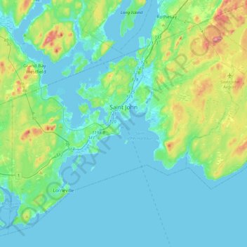
Nome: Mapa topográfico Saint John, altitude, relevo.
Local: Saint John, Saint John County, New Brunswick, Canada (45.14150 -66.23940 45.37693 -65.83886)
Altitude média: 39 m
Altitude mínima: -8 m
Altitude máxima: 223 m
Obrigado por apoiar este site ❤️
Faça uma doação
Faça uma doação
Outros mapas topográficos
Clique em um mapa para visualizar sua topografia, sua altitude e seu relevo.
Saint John
Canada > New Brunswick > Saint John
The topography surrounding Saint John is hilly; a result of the influence of two coastal mountain ranges which run along the Bay of Fundy – the St. Croix Highlands and the Caledonia Highlands. The soil throughout the region is extremely rocky with frequent granite outcrops. The coastal plain hosts numerous…
Altitude média: 44 m