
Faça uma doação
Mapa topográfico Bridport
Clique no mapa para exibir a altitude.
Faça uma doação
Bridport
Bridport is in the county of Dorset in South West England. Measured directly, it is about 14 miles (23 km) west of the county town Dorchester, 15.5 miles (25 km) SSW of Yeovil in Somerset, 33 miles (53 km) east of Exeter in Devon and 1.5 miles (2.4 km) inland from the English Channel at West Bay. The town centre is sited between the small River Brit and its tributary the Asker, about 0.5 miles (0.8 km) north of their confluence, at an altitude of 10–15 metres (33–49 ft). Another small tributary, the River Simene, also joins the Brit to the west of the town centre.
Faça uma doação
Sobre este mapa
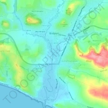
Nome: Mapa topográfico Bridport, altitude, relevo.
Local: Bridport, Dorset, England, United Kingdom (50.70846 -2.77110 50.74499 -2.73756)
Altitude média: 32 m
Altitude mínima: -3 m
Altitude máxima: 128 m
Faça uma doação
Outros mapas topográficos
Clique em um mapa para visualizar sua topografia, sua altitude e seu relevo.