
Faça uma doação
Mapa topográfico St Ives
Clique no mapa para exibir a altitude.
Faça uma doação
Sobre este mapa
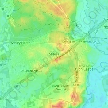
Nome: Mapa topográfico St Ives, altitude, relevo.
Local: St Ives, Dorset, England, BH24 2NE, United Kingdom (50.81687 -1.84370 50.85687 -1.80370)
Altitude média: 24 m
Altitude mínima: 8 m
Altitude máxima: 52 m
Faça uma doação
Outros mapas topográficos
Clique em um mapa para visualizar sua topografia, sua altitude e seu relevo.
Faça uma doação
Faça uma doação
Isle of Portland
United Kingdom > England > Dorset > Wyke Regis
In Museums Without Walls, Jonathan Meades declares that "Portland is a bulky chunk of geological, social, topographical and demographic weirdness. It is the obverse of a beauty spot. 'Beauty' in this construction implies the picturesque. Portland is gloriously bereft of this quality. It is awesome. There is…
Altitude média: 11 m
Faça uma doação
Faça uma doação
Bridport
United Kingdom > England > Dorset
Bridport is in the county of Dorset in South West England. Measured directly, it is about 14 miles (23 km) west of the county town Dorchester, 15.5 miles (25 km) SSW of Yeovil in Somerset, 33 miles (53 km) east of Exeter in Devon and 1.5 miles (2.4 km) inland from the English Channel at West Bay. The town…
Altitude média: 32 m
Faça uma doação