
Faça uma doação
Mapa topográfico Van Horn
Clique no mapa para exibir a altitude.
Faça uma doação
Van Horn
According to the United States Census Bureau, the town has a total area of 2.8 square miles (7.3 km2), all land. Threemile Peak, elevation 4,868 feet (1,484 m), rises to the northwest overlooking the town.
Faça uma doação
Sobre este mapa
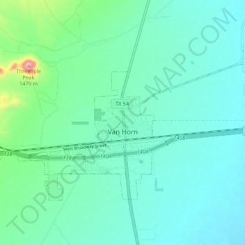
Nome: Mapa topográfico Van Horn, altitude, relevo.
Local: Van Horn, Culberson County, Texas, 79855, United States (31.02326 -104.86794 31.06712 -104.78595)
Altitude média: 1.242 m
Altitude mínima: 1.193 m
Altitude máxima: 1.479 m
Faça uma doação
Outros mapas topográficos
Clique em um mapa para visualizar sua topografia, sua altitude e seu relevo.
Guadalupe Peak
United States > Texas > Culberson County
Guadalupe Peak, also known as Signal Peak, is the highest natural point in Texas, with an elevation of 8,751 feet (2,667 m) above sea level. It is located in Guadalupe Mountains National Park, and is part of the Guadalupe Mountains range in southeastern New Mexico and West Texas. The mountain is about 90 miles…
Altitude média: 2.150 m