
Faça uma doação
Mapa topográfico El Capitan
Clique no mapa para exibir a altitude.
Faça uma doação
Sobre este mapa
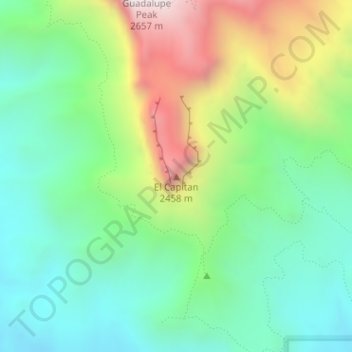
Nome: Mapa topográfico El Capitan, altitude, relevo.
Local: El Capitan, Culberson County, Texas, 79847, United States (31.87729 -104.85805 31.87739 -104.85795)
Altitude média: 1.916 m
Altitude mínima: 1.564 m
Altitude máxima: 2.613 m
Faça uma doação
Outros mapas topográficos
Clique em um mapa para visualizar sua topografia, sua altitude e seu relevo.
Van Horn
United States > Texas > Culberson County
According to the United States Census Bureau, the town has a total area of 2.8 square miles (7.3 km2), all land. Threemile Peak, elevation 4,868 feet (1,484 m), rises to the northwest overlooking the town.
Altitude média: 1.242 m
Guadalupe Mountains National Park
United States > Texas > Culberson County
The Guadalupe Mountains reach their highest point at Guadalupe Peak, the highest point in Texas, with an elevation of 8,751 feet (2,667 m). The range lies southeast of the Sacramento Mountains and east of the Brokeoff Mountains. The mountain range extends north-northwest and northeast from Guadalupe Peak in…
Altitude média: 1.484 m
Faça uma doação
Van Horn
United States > Texas > Culberson County
According to the United States Census Bureau, the town has a total area of 2.8 square miles (7.3 km2), all land. Threemile Peak, elevation 4,868 feet (1,484 m), rises to the northwest overlooking the town.
Altitude média: 1.242 m
Van Horn
United States > Texas > Culberson County
According to the United States Census Bureau, the town has a total area of 2.8 square miles (7.3 km2), all land. Threemile Peak, elevation 4,868 feet (1,484 m), rises to the northwest overlooking the town.
Altitude média: 1.242 m