
Faça uma doação
Mapa topográfico Stonor
Clique no mapa para exibir a altitude.
Faça uma doação
Sobre este mapa
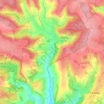
Nome: Mapa topográfico Stonor, altitude, relevo.
Altitude média: 145 m
Altitude mínima: 63 m
Altitude máxima: 204 m
Faça uma doação
Outros mapas topográficos
Clique em um mapa para visualizar sua topografia, sua altitude e seu relevo.
Whitchurch-on-Thames
United Kingdom > England > Oxfordshire > South Oxfordshire > Whitchurch-on-Thames
Altitude média: 84 m
Clifton Hampden
United Kingdom > England > Oxfordshire > South Oxfordshire > Clifton Hampden
Altitude média: 58 m
Faça uma doação
Harpsden Wood
United Kingdom > England > Oxfordshire > South Oxfordshire > Henley-on-Thames > Harpsden
Altitude média: 63 m
Watlington Hill
United Kingdom > England > Oxfordshire > South Oxfordshire > Watlington
Altitude média: 189 m
Kingwood Common
United Kingdom > England > Oxfordshire > South Oxfordshire > Highmoor
Altitude média: 125 m
Faça uma doação
Goring-on-Thames
United Kingdom > England > Oxfordshire > South Oxfordshire > Goring-on-Thames
Altitude média: 87 m
Cowleaze Wood
United Kingdom > England > Oxfordshire > South Oxfordshire > Lewknor
Altitude média: 209 m
Faça uma doação
Sonning Eye
United Kingdom > England > Oxfordshire > South Oxfordshire > Dunsden Green > Sonning Eye
Altitude média: 44 m
Faça uma doação
Faça uma doação
Brightwell-cum-Sotwell
United Kingdom > England > Oxfordshire > South Oxfordshire
Altitude média: 54 m
Faça uma doação
Faça uma doação
Faça uma doação
Kidmore End
United Kingdom > England > Oxfordshire > South Oxfordshire > Kidmore End
Altitude média: 94 m
Faça uma doação
Chinnor Quarry 2B
United Kingdom > England > Oxfordshire > South Oxfordshire > Kingston Blount > Crowell
Altitude média: 163 m
Edmonds Park
United Kingdom > England > Oxfordshire > South Oxfordshire > Didcot > East Hagbourne
Altitude média: 68 m
Faça uma doação
Rotherfield Peppard
United Kingdom > England > Oxfordshire > South Oxfordshire > Rotherfield Peppard
Altitude média: 115 m
Faça uma doação
Shirburn
United Kingdom > England > Oxfordshire > South Oxfordshire
Shirburn is a village and civil parish about 6 miles (10 km) south of Thame in Oxfordshire. It contains the Grade I listed, 14th-century Shirburn Castle, along with its surrounding, Grade II listed park, and a parish church, the oldest part of which is from the Norman period. The parish has a high altitude by…
Altitude média: 140 m
Sonning Common
United Kingdom > England > Oxfordshire > South Oxfordshire > Sonning Common
Altitude média: 88 m
Faça uma doação
Faça uma doação
East Hagbourne
United Kingdom > England > Oxfordshire > South Oxfordshire > East Hagbourne
Altitude média: 62 m
Faça uma doação
Brightwell Baldwin
United Kingdom > England > Oxfordshire > South Oxfordshire > Cuxham
Altitude média: 97 m
Stanton St John
United Kingdom > England > Oxfordshire > South Oxfordshire > Stanton St John
Altitude média: 86 m
Faça uma doação
Faça uma doação
Faça uma doação
Swyncombe
United Kingdom > England > Oxfordshire > South Oxfordshire > Swyncombe
Altitude média: 174 m
Aston Rowant Nature Reserve
United Kingdom > England > Oxfordshire > South Oxfordshire > Lewknor
Altitude média: 192 m
Faça uma doação
Warborough
United Kingdom > England > Oxfordshire > South Oxfordshire > Warborough
Altitude média: 53 m
Faça uma doação
Holly Wood
United Kingdom > England > Oxfordshire > South Oxfordshire > Stanton St John
Altitude média: 80 m