
Mapa topográfico Little Wittenham
Clique no mapa para exibir a altitude.
Sobre este mapa
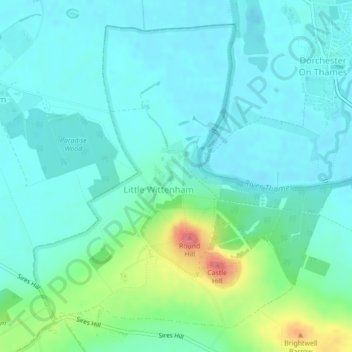
Nome: Mapa topográfico Little Wittenham, altitude, relevo.
Altitude média: 61 m
Altitude mínima: 43 m
Altitude máxima: 129 m
Outros mapas topográficos
Clique em um mapa para visualizar sua topografia, sua altitude e seu relevo.
Harpsden Wood
United Kingdom > England > Oxfordshire > South Oxfordshire > Henley-on-Thames > Harpsden
Altitude média: 63 m
Kingwood Common
United Kingdom > England > Oxfordshire > South Oxfordshire > Highmoor
Altitude média: 125 m
Waterperry
United Kingdom > England > Oxfordshire > South Oxfordshire > Waterstock
Altitude média: 63 m
Cane End
United Kingdom > England > Oxfordshire > South Oxfordshire > Gallowstree Common
Altitude média: 108 m
Cowleaze Wood
United Kingdom > England > Oxfordshire > South Oxfordshire > Lewknor
Altitude média: 209 m
Wittenham Clumps
United Kingdom > England > Oxfordshire > South Oxfordshire > Little Wittenham
Altitude média: 65 m
Mongewell
United Kingdom > England > Oxfordshire > South Oxfordshire > Crowmarsh Gifford
Altitude média: 59 m
Sonning Eye
United Kingdom > England > Oxfordshire > South Oxfordshire > Dunsden Green > Sonning Eye
Altitude média: 44 m
Preston Crowmarsh
United Kingdom > England > Oxfordshire > South Oxfordshire > Benson
Altitude média: 58 m
Ewelme Park
United Kingdom > England > Oxfordshire > South Oxfordshire > Swyncombe
Altitude média: 172 m
Chalkhouse Green
United Kingdom > England > Oxfordshire > South Oxfordshire > Kidmore End
Altitude média: 83 m
Wet n Wild Oxford
United Kingdom > England > Oxfordshire > South Oxfordshire > Berinsfield
Altitude média: 51 m
Gatehampton
United Kingdom > England > Oxfordshire > South Oxfordshire > Goring-on-Thames
Altitude média: 88 m
Baldon Row
United Kingdom > England > Oxfordshire > South Oxfordshire > Toot Baldon
Altitude média: 73 m
Little Haseley
United Kingdom > England > Oxfordshire > South Oxfordshire > Great Haseley
Altitude média: 73 m
Newnham Murren
United Kingdom > England > Oxfordshire > South Oxfordshire > Crowmarsh Gifford
Altitude média: 59 m
Christmas Common
United Kingdom > England > Oxfordshire > South Oxfordshire > Watlington
Christmas Common is a hamlet in Watlington civil parish, Oxfordshire about 7+1⁄2 miles (12 km) south of Thame in Oxfordshire, close to the boundary with Buckinghamshire. The hamlet is 812 feet (247 m) above sea level on an escarpment of the Chiltern Hills. Because of its elevation, Christmas Common has two…
Altitude média: 192 m
Chinnor Quarry 2B
United Kingdom > England > Oxfordshire > South Oxfordshire > Kingston Blount > Crowell
Altitude média: 163 m
Kingston Stert
United Kingdom > England > Oxfordshire > South Oxfordshire > Aston Rowant
Altitude média: 96 m
Woodperry
United Kingdom > England > Oxfordshire > South Oxfordshire > Stanton St John
Altitude média: 89 m
Edmonds Park
United Kingdom > England > Oxfordshire > South Oxfordshire > Didcot > East Hagbourne
Altitude média: 68 m
Overy
United Kingdom > England > Oxfordshire > South Oxfordshire > Dorchester-on-Thames
Altitude média: 55 m
Witheridge Hill
United Kingdom > England > Oxfordshire > South Oxfordshire > Highmoor > Witheridge Hill
Altitude média: 144 m
Path Hill
United Kingdom > England > Oxfordshire > South Oxfordshire > Whitchurch Hill
Altitude média: 99 m
Burcot
United Kingdom > England > Oxfordshire > South Oxfordshire > Clifton Hampden
Altitude média: 59 m
Brookhampton
United Kingdom > England > Oxfordshire > South Oxfordshire > Chiselhampton > Brookhampton
Altitude média: 59 m
Peppard Common
United Kingdom > England > Oxfordshire > South Oxfordshire > Rotherfield Peppard
Altitude média: 108 m