
Faça uma doação
Mapa topográfico Lancaster
Clique no mapa para exibir a altitude.
Faça uma doação
Lancaster
Lancaster is situated within the Blackland Prairie region of Texas, which is characterized by level to gently rolling topography. Ten Mile Creek and its tributaries are major drainage features in and around the city. Because the area was used for farming and other agricultural businesses, much of the natural vegetation has been cleared. Areas near creeks have retained some of their original tree cover, which includes pecan trees, cedar elms, and several species of oaks.
Faça uma doação
Sobre este mapa
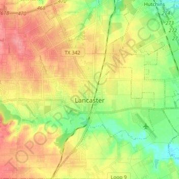
Nome: Mapa topográfico Lancaster, altitude, relevo.
Local: Lancaster, Dallas County, Texas, United States (32.54691 -96.82324 32.64969 -96.71206)
Altitude média: 165 m
Altitude mínima: 127 m
Altitude máxima: 203 m
Faça uma doação
Outros mapas topográficos
Clique em um mapa para visualizar sua topografia, sua altitude e seu relevo.
Faça uma doação
Faça uma doação
Dallas
United States > Texas > Dallas County > Dallas
Dallas and its surrounding area are mostly flat. The city lies at elevations ranging from 450 to 550 feet (137 to 168 m) above sea level. The western edge of the Austin Chalk Formation, a limestone escarpment (also known as the "White Rock Escarpment"), rises 230 feet (70 m) and runs roughly north–south…
Altitude média: 158 m
Faça uma doação
Faça uma doação
Faça uma doação
Faça uma doação