
Faça uma doação
Mapa topográfico Dallas
Clique no mapa para exibir a altitude.
Faça uma doação
Dallas
Dallas and its surrounding area are mostly flat. The city lies at elevations ranging from 450 to 550 feet (137 to 168 m) above sea level. The western edge of the Austin Chalk Formation, a limestone escarpment (also known as the "White Rock Escarpment"), rises 230 feet (70 m) and runs roughly north–south through Dallas County. South of the Trinity River, the uplift is particularly noticeable in the neighborhoods of Oak Cliff and the adjacent cities of Cockrell Hill, Cedar Hill, Grand Prairie, and Irving. Marked variations in terrain are also found in cities immediately to the west in Tarrant County surrounding Fort Worth, as well as along Turtle Creek north of Downtown.
Faça uma doação
Sobre este mapa
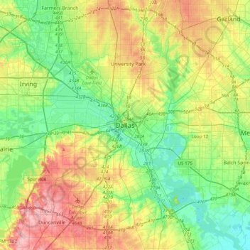
Nome: Mapa topográfico Dallas, altitude, relevo.
Local: Dallas, Dallas County, Texas, 75242, United States (32.61627 -96.95686 32.93627 -96.63686)
Altitude média: 158 m
Altitude mínima: 110 m
Altitude máxima: 238 m
Faça uma doação
Outros mapas topográficos
Clique em um mapa para visualizar sua topografia, sua altitude e seu relevo.
Klyde Warren Park-Arts District PID
United States > Texas > Dallas County > Dallas
Altitude média: 143 m
Faça uma doação