
Mapa topográfico Hewish
Clique no mapa para exibir a altitude.
Sobre este mapa
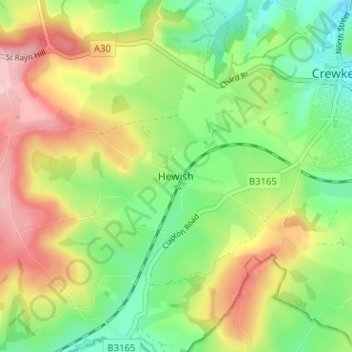
Nome: Mapa topográfico Hewish, altitude, relevo.
Local: Hewish, Somerset, England, TA18 8QU, United Kingdom (50.85245 -2.84542 50.89245 -2.80542)
Altitude média: 136 m
Altitude mínima: 59 m
Altitude máxima: 240 m
Outros mapas topográficos
Clique em um mapa para visualizar sua topografia, sua altitude e seu relevo.
Priddy
United Kingdom > England > Somerset
The village lies in a small hollow near the summit of the Mendip range of hills, at an elevation of nearly 1,000 feet (300 m) above sea-level, and has evidence of occupation since neolithic times. There are remains of lead mining activities and caves in the limestone beneath the village.
Altitude média: 206 m
Small Brook
United Kingdom > England > Somerset > South Somerset > Haselbury Plucknett
Altitude média: 48 m
St. Michael's Tower
United Kingdom > England > Somerset > Mendip District > Glastonbury
Altitude média: 33 m
Quantock Hills National Landscape
United Kingdom > England > Somerset > Over Stowey
Altitude média: 116 m
Mells Park
United Kingdom > England > Somerset > Vobster
The architect Edwin Lutyens had known the Horners, and Mells Park, since 1896. In 1918 he unsuccessfully tried to persuade the Horners to rebuild Park House. However, Reginald McKenna, the chairman of Midland Bank, and formerly Home Secretary and Chancellor of the Exchequer under Asquith, was married to Pamela…
Altitude média: 134 m