
Mapa topográfico Wells
Clique no mapa para exibir a altitude.
Sobre este mapa
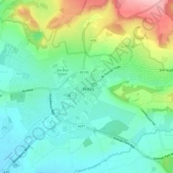
Nome: Mapa topográfico Wells, altitude, relevo.
Local: Wells, Somerset, England, United Kingdom (51.19764 -2.66890 51.22207 -2.62136)
Altitude média: 69 m
Altitude mínima: 16 m
Altitude máxima: 186 m
Outros mapas topográficos
Clique em um mapa para visualizar sua topografia, sua altitude e seu relevo.
Huxham Green
United Kingdom > England > Somerset > Mendip District > East Pennard
Altitude média: 65 m
Chard
United Kingdom > England > Somerset
Chard is a town and a civil parish in the English county of Somerset. It lies on the A30 road near the Devon and Dorset borders, 15 miles (24 km) south west of Yeovil. The parish has a population of approximately 13,000 and, at an elevation of 121 metres (397 ft), Chard is the southernmost and one of the…
Altitude média: 135 m
Small Brook
United Kingdom > England > Somerset > South Somerset > Haselbury Plucknett
Altitude média: 48 m
Hill End
United Kingdom > England > Somerset > South Somerset > Hardington Mandeville > Hill End
Altitude média: 62 m
St. Michael's Tower
United Kingdom > England > Somerset > Mendip District > Glastonbury
Altitude média: 33 m
Midway
United Kingdom > England > Somerset > Mendip District > Stoke St. Michael > Midway
Altitude média: 218 m
Kingsbury Regis
United Kingdom > England > Somerset > South Somerset > Milborne Port
Altitude média: 97 m